Horseshoe Curve: Difference between revisions
Jump to navigation
Jump to search
No edit summary |
No edit summary |
||
| Line 6: | Line 6: | ||
'''To Bristol''': [[A Drain]]<br> | '''To Bristol''': [[A Drain]]<br> | ||
'''To Avonmouth''': [[Woodwell Road]] | '''To Avonmouth''': [[Woodwell Road]] | ||
== 1960s == | |||
<gallery> | |||
Image:Horseshoe Curve5.jpg|A view of the area from the early 1960s when the line was still double track. ''© [[:Category:John Thorn|John Thorn]]'' | |||
</gallery> | |||
== 1970s == | == 1970s == | ||
<gallery> | <gallery> | ||
| Line 21: | Line 25: | ||
[[Category:Gerald Peacock]] | [[Category:Gerald Peacock]] | ||
[[Category:The Severn Beach Line]] | [[Category:The Severn Beach Line]] | ||
[[Category:John Thorn]] | |||
Latest revision as of 16:59, 13 June 2008
<googlemap lat="51.490469" lon="-2.662125"> 51.488064, -2.662897, Horseshoe Curve </googlemap>
To Bristol: A Drain
To Avonmouth: Woodwell Road
1960s
-
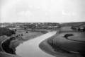 A view of the area from the early 1960s when the line was still double track. © John Thorn

1970s
-
 A Class 37 heads for Bristol with a freight. © Andy Kirkham
 -

-


Gallery
-
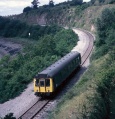
 Horseshoe Curve photographed at a time when an engineering possession at Filton Abbey Wood meant services were diverted via Avonmouth. © Gerald Peacock
 -


