Highbridge and Burnham
Jump to navigation
Jump to search
To Weston Super Mare: Market Street
To Burnham: Burnham on Sea
To the Southwest: Dunball
History
Opened as Highbridge on 14th June 1841. Renamed Highbridge West on 5th May 1950, Highbridge and Burnham-on-Sea on 30th June 1962, Highbridge on 6th May 1974 and Highbridge and Burnham on 17th May 1991.
Platform 1 is 217 yards long, and platform 2 is 167 yards long. The goods loop is 1638 ft long and has a 25mph speed limit.
Track Plans
-
 A track plan of Highbridge from 1988

1980s
-
 The original station buildings. 19.7.81 © Martin Potter

2005
6.2.05
-
 The approach to Highbridge (GWR) station. The S&D station site is under the housing beyond the footbridge. The footbridge is a truncated version, it would have at one time connected the GWR and S&D stations.
 -
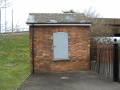 An old office stands on the approach road.
 -
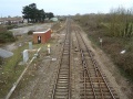
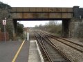 Looking north from the end of the platform. The S&D railway line crossed the GWR one on the level at this spot. The junction in this photo is called Highbridge East and allows freight trains to use the loop line at the west of the station as a refuge. The bridge carries Market Street across the railway.
 -
 The view south from the same spot. The down main was blocked by an engineering possession.
 -
 A look at the truncated end of the footbridge and the housing that stands on the S&D Railway station site. A signal box stood here and controlled both the GWR and S&D lines. It closed on 20th March 1972.
 -
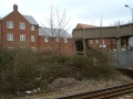
 The S&D line cossed the GWR at this spot and curved to the left of this photo close to where the relay room is. Highbridge Goods Shed stood at the spot now occupied by the semi-circular shed in the distance. It closed to traffic on 2nd November 1964.
 -
 The Kwik Save in the distance stands on the route of the S&D route to Burnham on Sea.
 -
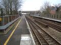
 A further look north from Highbridge station.
 -
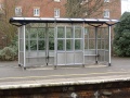
 Shelters on platform 2.
 -
 The shelter on platform 1.
 -
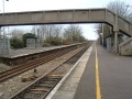
 Looking south from the footbridge. The down main has a warning beacon on it. The platforms narrow where the station crosses the River Brue. The up goods loop is bi-directional and can be used by trains travelling south.
 -
 The view north from the bridge across the River Brue.
 -
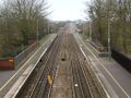
 The view south from the end of platform 2. Highbridge West junction is at the other end of the goods loop.
 -
 The view north from the same spot.
 -
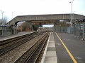
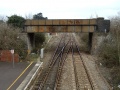 A last look at the roadbridge at the north end of Highbridge station. A repetition of previous photos, included simply because I really like the way this one came out :)


