Marsh Lane: Difference between revisions
Jump to navigation
Jump to search
No edit summary |
BristleGWR (talk | contribs) No edit summary |
||
| (One intermediate revision by one other user not shown) | |||
| Line 4: | Line 4: | ||
</googlemap> | </googlemap> | ||
</div> | </div> | ||
'''To Parson Street Junction''': [[ | '''To Parson Street Junction''': [[Portbury Junction]]<br> | ||
'''To Portishead''': [[Royal Portbury Dock Road]] | '''To Portishead''': [[Royal Portbury Dock Road]] | ||
== History == | == History == | ||
| Line 10: | Line 10: | ||
== Gallery == | == Gallery == | ||
<gallery> | <gallery> | ||
Image:Marsh Lane1.jpg|The view towards [[Pill]] with the | Image:Marsh Lane1.jpg|The view towards [[Pill]] with the M5 viaduct in the background. | ||
Image:Marsh Lane2.jpg|The view towards [[Portishead]]. Believe it or not there was still track underneath all that lot! | Image:Marsh Lane2.jpg|The view towards [[Portishead]]. Believe it or not there was still track underneath all that lot! | ||
</gallery> | </gallery> | ||
[[Category:Bridges]] | [[Category:Bridges]] | ||
[[Category:B&PP&RC]] | [[Category:B&PP&RC]] | ||
Revision as of 13:13, 31 August 2008
<googlemap lat="51.485018" lon="-2.705812"> 51.481851, -2.70637, Marsh Lane </googlemap>
To Parson Street Junction: Portbury Junction
To Portishead: Royal Portbury Dock Road
History
Gallery
-
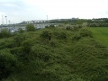 The view towards Pill with the M5 viaduct in the background.
 -
 The view towards Portishead. Believe it or not there was still track underneath all that lot!

