Ocean Bridge: Difference between revisions
Jump to navigation
Jump to search
New page: <div style="float:right"> <googlemap lat="51.742071" lon="-2.295198"> 51.744157, -2.295456, Ocean Bridge </googlemap> </div> '''To Yate''': Lower Fields<br> '''To the North''': [[Stone... |
No edit summary |
||
| (8 intermediate revisions by the same user not shown) | |||
| Line 1: | Line 1: | ||
<div style="float:right"> | <div style="float:right"> | ||
<googlemap lat="51. | <googlemap lat="51.736955" lon="-2.293654"> | ||
51. | 51.743612, -2.293718, Ocean Bridge | ||
</googlemap> | </googlemap> | ||
</div> | </div> | ||
'''To | '''To the Severn''': [[Ocean Railway Bridge]] | ||
'''To the | <br>'''To the Thames''': [[Nutshell Bridge]] | ||
== info == | |||
This bridge was built in 2012 and replaced a fixed one. | |||
== Gallery == | == Gallery == | ||
6.6.14 | |||
<gallery> | <gallery> | ||
Image: | Image:OceanBridge6.jpg|The bridge viewed from the east. | ||
Image:OceanBridge7.jpg| | |||
Image:OceanBridge8.jpg| | |||
Image:OceanBridge9.jpg|The view towards the Severn. | |||
Image:OceanBridge10.jpg|The view towards the Thames. | |||
</gallery> | </gallery> | ||
[[Category: | [[Category:Stroudwater Navigation]] | ||
Latest revision as of 22:09, 26 June 2014
<googlemap lat="51.736955" lon="-2.293654"> 51.743612, -2.293718, Ocean Bridge </googlemap>
To the Severn: Ocean Railway Bridge
To the Thames: Nutshell Bridge
info
This bridge was built in 2012 and replaced a fixed one.
Gallery
6.6.14
-
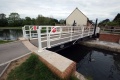 The bridge viewed from the east.
 -

-

-
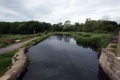 The view towards the Severn.
 -
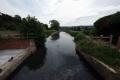 The view towards the Thames.


