Freestone Road: Difference between revisions
Jump to navigation
Jump to search
New page: <div style="float:right"> <googlemap lat="51.452777" lon="-2.574062"> 51.45162, -2.574577, Freestone Road </googlemap> </div> '''To Temple Meads''': Bristol East Power Box<br> '''To Ba... |
No edit summary |
||
| (5 intermediate revisions by the same user not shown) | |||
| Line 1: | Line 1: | ||
'''To Temple Meads''': [[Midland Junction]]<br> | |||
'''To Bath, the North or Wales''': [[South Wales Junction]] | |||
== 2004 == | |||
9.5.04 | |||
'''To Temple Meads''': [[ | |||
'''To Bath, the North or Wales''': [[ | |||
== | |||
<gallery> | <gallery> | ||
Image:Freestone Road1.jpg|A black hole under the railway. | Image:Freestone Road1.jpg|A black hole under the railway. | ||
Image:Freestone Road2.jpg|A quick check to see if anyone was living in here.. | Image:Freestone Road2.jpg|A quick check to see if anyone was living in here.. | ||
Image:Freestone Road3.jpg|.. then through to the other side to get this photo. | Image:Freestone Road3.jpg|.. then through to the other side to get this photo. | ||
</gallery> | |||
== 2007 == | |||
1.7.07 | |||
<gallery> | |||
Image:Freestone Road4.jpg|Another photo of the bridge taken three years after the first. | |||
</gallery> | </gallery> | ||
[[Category:Bridges]] | [[Category:Bridges]] | ||
[[Category:GWR]] | [[Category:GWR]] | ||
Latest revision as of 11:37, 12 July 2022
To Temple Meads: Midland Junction
To Bath, the North or Wales: South Wales Junction
2004
9.5.04
-
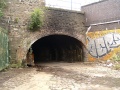 A black hole under the railway.
 -
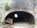 A quick check to see if anyone was living in here..
 -
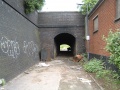 .. then through to the other side to get this photo.


2007
1.7.07
-
 Another photo of the bridge taken three years after the first.
