Cattle Market Road: Difference between revisions
Jump to navigation
Jump to search
No edit summary |
|||
| (One intermediate revision by the same user not shown) | |||
| Line 1: | Line 1: | ||
'''To Bristol''': [[Temple Meads]]<br> | '''To Bristol''': [[Temple Meads]]<br> | ||
'''To the Southwest''': [[The New Cut]] | '''To the Southwest''': [[The New Cut]] | ||
== History == | == History == | ||
Part of [[Temple Meads]] station is built over [[Cattle Market Road]]. The road curves in a slight crescent as it goes under the station. A series of steel girders form the bridge which is 118m 35ch from [[Paddington]]. | Part of [[Temple Meads]] station is built over [[Cattle Market Road]]. The road curves in a slight crescent as it goes under the station. A series of steel girders form the bridge which is 118m 35ch from [[Paddington railway station|Paddington]]. | ||
== 2004 == | == 2004 == | ||
8.8.04 | 8.8.04 | ||
Latest revision as of 12:39, 12 July 2022
To Bristol: Temple Meads
To the Southwest: The New Cut
History
Part of Temple Meads station is built over Cattle Market Road. The road curves in a slight crescent as it goes under the station. A series of steel girders form the bridge which is 118m 35ch from Paddington.
2004
8.8.04
-
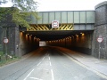 The bridge taking Temple Meads across Cattle Market Road.
 -
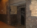 There are a couple of doorways either side of the road that lead into the station.
 -
 Wouldn't it be nice to see what's beyond the doors? :)
 -
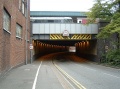 The bridge viewed from the other side. The Wessex Class 31 stabled in the bay platform gives away that this photo was taken on a Sunday. 8.9.04.
 -
 Standing back where I started in the first pic and looking along the embankment towards the Post Office sorting building that dominates the skyline in so many people's Temple Meads photos.


