Ebley Mill Bridge: Difference between revisions
Jump to navigation
Jump to search
Created page with "'''To the Severn''': Ebley Wharf <br>'''To the Thames''': Ebley Mills Pedestrian Bridge and Floodgate == info == Also known as Cloth Mills Bridge. == Gallery == 6.6.14..." |
No edit summary |
||
| (3 intermediate revisions by the same user not shown) | |||
| Line 3: | Line 3: | ||
== info == | == info == | ||
Also known as Cloth Mills Bridge. | Also known as Cloth Mills Bridge. | ||
== | == 2012 == | ||
<gallery> | <gallery> | ||
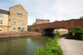
Image: | Image:Ebley Mill Bridge1.jpg|The view west from the bridge. 8.5.12 | ||
Image:Ebley Mill Bridge2.jpg|And the view east. The developers of the houses being built on this site paid for Ebley Bridge to be built. | |||
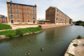
Image:Ebley Mill1.jpg|The mill is now the home of Stroud Council. | |||
</gallery> | |||
== 2014 == | |||
<gallery> | |||
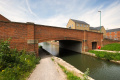
Image:EbleyMillBridge3.jpg|Some photos of the actual bridge at this location. 6.6.14 | |||
Image:EbleyMillBridge4.jpg| | |||
Image:EbleyMill2.jpg|The development seen in the 2012 photos is nearly complete. [[Ebley Mills Pedestrian Bridge and Floodgate]] can be seen in the distance. | |||
Image:EbleyMill3.jpg| | |||
</gallery> | </gallery> | ||
[[Category:Stroudwater Navigation]] | [[Category:Stroudwater Navigation]] | ||
Latest revision as of 21:18, 14 July 2022
To the Severn: Ebley Wharf
To the Thames: Ebley Mills Pedestrian Bridge and Floodgate
info
Also known as Cloth Mills Bridge.
2012
-
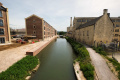
 The view west from the bridge. 8.5.12
 -
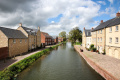
 And the view east. The developers of the houses being built on this site paid for Ebley Bridge to be built.
 -
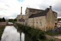 The mill is now the home of Stroud Council.


2014
-
 Some photos of the actual bridge at this location. 6.6.14
 -
-
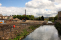
 The development seen in the 2012 photos is nearly complete. Ebley Mills Pedestrian Bridge and Floodgate can be seen in the distance.
 -