Foundry Lock: Difference between revisions
Jump to navigation
Jump to search
Created page with '<div style="float:right"> <googlemap lat="51.736703" lon="-2.23443"> 51.743293, -2.234945, Foundry Lock </googlemap> </div> '''To the Severn''': Dudbridge Lock <br>'''To the …' |
No edit summary |
||
| (One intermediate revision by the same user not shown) | |||
| Line 1: | Line 1: | ||
'''To the Severn''': [[Dudbridge Lock]] | '''To the Severn''': [[Dudbridge Lock]] | ||
<br>'''To the Thames''': [[Chestnut Lane Bridge]] | <br>'''To the Thames''': [[Chestnut Lane Bridge]] | ||
== Info == | |||
Now more likely to be referred to as Dudbridge Upper Lock. | |||
== Gallery == | |||
<gallery> | |||
Image:Foundry Lock1.jpg|A zoomed view of Foundry Lock undergoing restoration. '''8.5.12''' | |||
Image:FoundryLock2.jpg|Approaching the now restored lock. '''6.6.14''' | |||
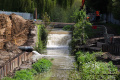
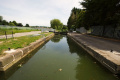
Image:FoundryLock3.jpg| | |||
Image:FoundryLock4.jpg|The view west. | |||
Image:FoundryLock5.jpg|The view east. | |||
Image:FoundryLock6.jpg|The channel on the right in this photo is part of a hydroelectric scheme installed when the lock was restored. | |||
Image:FoundryLock7.jpg| | |||
</gallery> | |||
[[Category:Stroudwater Navigation]] | [[Category:Stroudwater Navigation]] | ||
Latest revision as of 19:53, 16 July 2022
To the Severn: Dudbridge Lock
To the Thames: Chestnut Lane Bridge
Info
Now more likely to be referred to as Dudbridge Upper Lock.
Gallery
-
 A zoomed view of Foundry Lock undergoing restoration. 8.5.12
 -
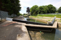
 Approaching the now restored lock. 6.6.14
 -
-
 The view west.
 -
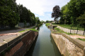
 The view east.
 -
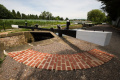
 The channel on the right in this photo is part of a hydroelectric scheme installed when the lock was restored.
 -