Westerleigh Viaduct: Difference between revisions
Jump to navigation
Jump to search
No edit summary |
No edit summary |
||
| (4 intermediate revisions by the same user not shown) | |||
| Line 1: | Line 1: | ||
'''To Bristol or Wales''': [[Broad Lane (1)|Broad Lane]] | |||
<br>'''To Yate or London''': [[Westerleigh Road(4)|Westerleigh West Junction]] | |||
'''To Bristol''': [[ | |||
<br>'''To Yate or London''': [[Westerleigh Road(4)|Westerleigh | |||
<br>'''To Mangotsfield''': [[Broad Lane]] | <br>'''To Mangotsfield''': [[Broad Lane]] | ||
<br>'''To Yate via LMS''':[[Nibley Lane (2)|Nibley Lane]] | <br>'''To Yate via LMS''':[[Nibley Lane (2)|Nibley Lane]] | ||
== Gallery == | == Gallery == | ||
28.2.04 | |||
<gallery> | <gallery> | ||
Image:Westerleigh Viaduct1.jpg|The ex Midland main line passes under Westerleigh Viaduct. The ex [[w:Great Western Railway|GWR]] mainline passes over the top. | Image:Westerleigh Viaduct1.jpg|The ex Midland main line passes under Westerleigh Viaduct. The ex [[w:Great Western Railway|GWR]] mainline passes over the top. | ||
Latest revision as of 18:12, 22 July 2022
To Bristol or Wales: Broad Lane
To Yate or London: Westerleigh West Junction
To Mangotsfield: Broad Lane
To Yate via LMS:Nibley Lane
Gallery
28.2.04
-
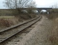 The ex Midland main line passes under Westerleigh Viaduct. The ex GWR mainline passes over the top.
 -
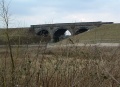 A second view.

