Durley Hill Footbridge: Difference between revisions
Jump to navigation
Jump to search
No edit summary |
|||
| (2 intermediate revisions by the same user not shown) | |||
| Line 1: | Line 1: | ||
'''To Bristol, the North or Wales''': [[A4174 Avon Ring Road]] | '''To Bristol, the North or Wales''': [[A4174 Avon Ring Road]] | ||
<br>'''To Bath''':[[Durley Lane]] | <br>'''To Bath''':[[Durley Lane]] | ||
| Line 25: | Line 20: | ||
<gallery> | <gallery> | ||
Image:Durley Hill Footbridge11.jpg|A slightly clearer look at the bridge. It has gained quite a bit more graffiti. | Image:Durley Hill Footbridge11.jpg|A slightly clearer look at the bridge. It has gained quite a bit more graffiti. | ||
Image:Durley Hill | Image:Durley Hill Footbridge12.jpg|The view towards west. | ||
Image:Durley Hill | Image:Durley Hill Footbridge13.jpg|The view east. | ||
</gallery> | </gallery> | ||
[[Category:Bridges]] | [[Category:Bridges]] | ||
Latest revision as of 21:01, 28 July 2022
To Bristol, the North or Wales: A4174 Avon Ring Road
To Bath:Durley Lane
History
Durley Hill Footbridge was the site of locomotive water troughs between 1898 and 1960.
2005
20.7.05
-
 This footbridge is sited along a footpath that runs from Durley Hill, Keynsham to the River Avon. © James Hyde
 -
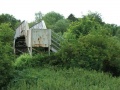
 A view of the bridge. © James Hyde
 -
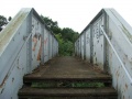
 A look at the steps. © James Hyde
 -
 The bridge viewed from the other side. © James Hyde
 -
 The view towards Keynsham with the Duke of Gloucester rushing towards the bridge. © James Hyde
 -
 And the view towards Bristol with the Duke of Gloucester rushing away from the bridge. © James Hyde
 -
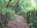
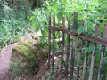
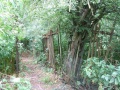 The next few photos show various footpaths and boundary fences at this location. © James Hyde
 -

-
-


2006
-
 A slightly clearer look at the bridge. It has gained quite a bit more graffiti.
 -
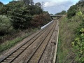 The view towards west.
 -
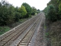 The view east.


