Kingsland Road: Difference between revisions
Jump to navigation
Jump to search
No edit summary |
|||
| (4 intermediate revisions by the same user not shown) | |||
| Line 1: | Line 1: | ||
'''To Avonside Wharf''': [[Barton Road]]<br> | '''To Avonside Wharf''': [[Barton Road]]<br> | ||
'''To Lawrence Hill Junction ''': [[Bristol City Council Refuse Transfer Station]] | '''To Lawrence Hill Junction ''': [[Bristol City Council Refuse Transfer Station]] | ||
== | == 2003 == | ||
18.11.03 | |||
<gallery> | <gallery> | ||
Image:Kingsland Road1.jpg|Standing on the bridge at '''Kingsland Road''' and looking north towards the [[Bristol City Council Refuse Transfer Station]]. | Image:Kingsland Road1.jpg|Standing on the bridge at '''Kingsland Road''' and looking north towards the [[Bristol City Council Refuse Transfer Station]]. | ||
| Line 17: | Line 13: | ||
26.9.06 | 26.9.06 | ||
<gallery> | <gallery> | ||
Image:Kingsland | Image:Kingsland Road5.jpg|An Autostitched view of Kingsland Road Bridge as viewed from the new Dings Railway Path | ||
Image:Kingsland | Image:Kingsland Road6.jpg|The view along the trackbed, looking towards [[Avon Street]]. | ||
Image:Kingsland | Image:Kingsland Road7.jpg|An alternative view. | ||
Image:Kingsland | Image:Kingsland Road8.jpg|Some graffiti under the bridge. | ||
Image:Kingsland Road9.jpg|A small plaque adorns a wall alongside the railway path. | |||
</gallery> | </gallery> | ||
[[Category:Bridges]] | [[Category:Bridges]] | ||
[[Category:Bristol & Gloucestershire Railway]] | [[Category:Bristol & Gloucestershire Railway]] | ||
Latest revision as of 17:18, 17 August 2022
To Avonside Wharf: Barton Road
To Lawrence Hill Junction : Bristol City Council Refuse Transfer Station
2003
18.11.03
-
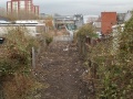 Standing on the bridge at Kingsland Road and looking north towards the Bristol City Council Refuse Transfer Station.
 -
 A general view of the bridge. There used to be a footbridge spanning the railway at this spot.
 -
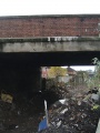 Looking under the bridge and suddenly requiring a face mask... An 'orrible stink was arising from the amount of rubbish piled underneath.
 -
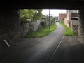
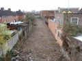 Standing on Kingsland Road and looking towards Barton Road. The remains of the railway leave a lovely scar right through the ramshackle buildings that sprung up each side of it.


2006
26.9.06
-
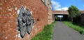 An Autostitched view of Kingsland Road Bridge as viewed from the new Dings Railway Path
 -
 The view along the trackbed, looking towards Avon Street.
 -
 An alternative view.
 -
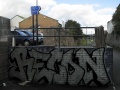 Some graffiti under the bridge.
 -
 A small plaque adorns a wall alongside the railway path.


