MediaWiki:Sidebar and Axbridge: Difference between pages
(Difference between pages)
No edit summary |
No edit summary |
||
| Line 1: | Line 1: | ||
<div style="float:right"> | |||
<googlemap lat="51.288389" lon="-2.816464"> | |||
51.288376, -2.816454, Axbridge | |||
</googlemap> | |||
</div> | |||
'''To Yatton''': [[A371 - Shute Shelve]]<br> | |||
'''To Cheddar''': [[A371 - Cheddar Road]]<br> | |||
== History == | |||
Opened on 3rd August [[1869]] and closed to goods traffic on 10th June [[1963]] and passengers on 9th September the same year. An original [[:Category:B&ER|Bristol & Exeter Railway]] signal box was replaced by a new one on 14th July [[1907]]. The route of the railway is now the A371 Axbridge bypass but luckily the station buildings and goods shed still survive. | |||
== 1960s == | |||
<gallery> | |||
Image:Axbridge2.jpg|A train approaches Axbridge.<br>''© [[:Category:Gerald Peacock|Gerald Peacock]]'' | |||
Image:Axbridge1.jpg|46525 with a train from [[Yatton]] enters Axbridge.<br>''© [[:Category:Gerald Peacock|Gerald Peacock]]'' | |||
Image:Axbridge3.jpg|The same loco shunting Conflats.<br>''© [[:Category:Gerald Peacock|Gerald Peacock]]'' | |||
Image:Axbridge4.jpg|The scene after track lifting had commenced. The [[1907]] signal box is visible in the photo. ''© [[:Category:John Thorn|John Thorn]]'' | |||
</gallery> | |||
== 2007 == | |||
<gallery> | |||
Image:Axbridge5.jpg|The surviving station building as photographed on 23.11.07. ''© MIke Smith [http://en.wikipedia.org/wiki/Image:Axbridge_Railway_Station.jpg some rights reserved]'' | |||
</gallery> | |||
[[Category:Cheddar Valley Line]] | |||
[[Category:Stations:Closed]] | |||
[[Category:Gerald Peacock]] | |||
[[Category:John Thorn]] | |||
Revision as of 22:41, 11 April 2026
<googlemap lat="51.288389" lon="-2.816464"> 51.288376, -2.816454, Axbridge </googlemap>
To Yatton: A371 - Shute Shelve
To Cheddar: A371 - Cheddar Road
History
Opened on 3rd August 1869 and closed to goods traffic on 10th June 1963 and passengers on 9th September the same year. An original Bristol & Exeter Railway signal box was replaced by a new one on 14th July 1907. The route of the railway is now the A371 Axbridge bypass but luckily the station buildings and goods shed still survive.
1960s
-
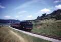 A train approaches Axbridge.
© Gerald Peacock -

-
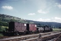 The same loco shunting Conflats.
© Gerald Peacock -
 The scene after track lifting had commenced. The 1907 signal box is visible in the photo. © John Thorn


2007
-
 The surviving station building as photographed on 23.11.07. © MIke Smith some rights reserved
