Watery Lane: Difference between revisions
Jump to navigation
Jump to search
No edit summary |
No edit summary |
||
| (One intermediate revision by the same user not shown) | |||
| Line 1: | Line 1: | ||
'''To Yate''': [[Broad Lane - Yate]] | '''To Yate''': [[Broad Lane - Yate]] | ||
<br>'''To the North''': [[Tanhouse Lane]] | <br>'''To the North''': [[Tanhouse Lane]] | ||
== Gallery == | == Gallery == | ||
14.11.03 | |||
<gallery> | <gallery> | ||
Image:Watery Lane2.jpg|The view south from '''Watery Lane''' bridge. In the distance are the bridges at [[Broad Lane - Yate|Broad Lane]]. | Image:Watery Lane2.jpg|The view south from '''Watery Lane''' bridge. In the distance are the bridges at [[Broad Lane - Yate|Broad Lane]]. | ||
Latest revision as of 19:45, 12 April 2026
To Yate: Broad Lane - Yate
To the North: Tanhouse Lane
Gallery
14.11.03
-
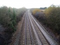 The view south from Watery Lane bridge. In the distance are the bridges at Broad Lane.
 -
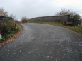 Looking across the bridge. The road is on an almost 90º bend at this spot.
 -
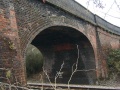 A look at the bridge itself. For a bridge built out of red brick it sure is a lot of different colours..
 -
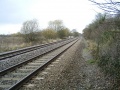 The view north.
 -
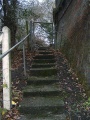 An access point to the railway.


