|
|
| Line 1: |
Line 1: |
| <div style="float:right">
| | '''To Yate''': [[Limekiln Road]] |
| <googlemap lat="51.466039" lon="-2.610025">
| | <br>'''To the North''': [[Westend Road]] |
| 51.464502, -2.610841, Clifton Down
| | == 17.5.05 == |
| </googlemap>
| |
| </div>
| |
| '''To Bristol''': [[Whiteladies Road]]<br> | |
| '''To Avonmouth''': [[St Johns Road]] | |
| == History == | |
| == Track Plans ==
| |
| <gallery> | | <gallery> |
| Image:Clifton Down Track Plan 1988.jpg|A track plan of Clifton Down and surrounding area from 1988. | | Image:Hall End Lane1.jpg|The view south. |
| | Image:Hall End Lane2.jpg|The view north. |
| | Image:Hall End Lane3.jpg|Zooming in on the next bridge along the line at [[Westend Road]]. |
| </gallery> | | </gallery> |
| == Gallery ==
| | |
| <gallery>
| | [[Category:B&GR]] |
| Image:Clifton Down1.jpg|Standing in the tunnel under [[Whiteladies Road]] looking towards [[Redland]].
| |
| Image:Clifton Down2.jpg|A general view of the station. Even on a sunny day the station is plunged into darkness by the buildings that have sprung up around it.
| |
| Image:Clifton Down3.jpg|The entrance to the station from [[Whiteladies Road]].
| |
| Image:Clifton Down4.jpg|One entrance to the station from the car park is through this rather wonderful gothic arch.
| |
| Image:Clifton Down5.jpg|Looking across the footbridge.
| |
| Image:Clifton Down6.jpg|Standing on the platform and looking back at the footbridge. The entrance on [[Whiteladies Road]] is in the top right corner, the dark tunnel being the road itself.
| |
| Image:150261-1.jpg|150261 stands in the station with a service to [[Temple Meads]].
| |
| Image:Clifton Down8.jpg|The platform shelter on Platform 1.
| |
| Image:Clifton Down9.jpg|The platform shelter on Platform 2.
| |
| Image:Clifton Down10.jpg|The signs on the station echo a time when trains from all over the country would head here to give people a day out at Bristol Zoo.
| |
| Image:Clifton Down11.jpg|The station building viewed from Platform 1.
| |
| Image:Clifton Down12.jpg|Another view of the platform side of the station.
| |
| Image:Clifton Down13.jpg|Viewed from the car park. The station building is now a bar.
| |
| Image:Clifton Down14.jpg|One corner of the building.
| |
| Image:Clifton Down15.jpg|Standing at the end of Platform 1 and looking towards [[St Johns Road]].
| |
| </gallery>
| |
| [[Category:Clifton Extension Railway]]
| |
| [[Category:GWR]] | |
| [[Category:MR]] | | [[Category:MR]] |
| [[Category:The Severn Beach Line]]
| |
| [[Category:Stations]]
| |
To Yate: Limekiln Road
To the North: Westend Road
17.5.05
-
The view south.
-
The view north.
-
Zooming in on the next bridge along the line at
Westend Road.
 The view south.
 The view north.
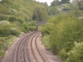 Zooming in on the next bridge along the line at Westend Road.

