Wotton Road: Difference between revisions
Jump to navigation
Jump to search
No edit summary |
No edit summary |
||
| (One intermediate revision by the same user not shown) | |||
| Line 1: | Line 1: | ||
'''To Yate''': [[Charfield]] | '''To Yate''': [[Charfield]] | ||
<br>'''To the North''': [[Charfield Loops]] | <br>'''To the North''': [[Charfield Loops]] | ||
== Gallery == | == Gallery == | ||
3.9.06 | 3.9.06 | ||
| Line 16: | Line 9: | ||
Image:Wotton Road4.jpg|The view north from the bridge showing the start of [[Charfield Loops]]. | Image:Wotton Road4.jpg|The view north from the bridge showing the start of [[Charfield Loops]]. | ||
</gallery> | </gallery> | ||
[[Category:Bridges]] | [[Category:Bridges]] | ||
[[Category:Bridges:Footbridges]] | [[Category:Bridges:Footbridges]] | ||
[[Category:B&GR]] | [[Category:B&GR]] | ||
[[Category:MR]] | [[Category:MR]] | ||
Latest revision as of 19:49, 12 April 2026
To Yate: Charfield
To the North: Charfield Loops
Gallery
3.9.06
-
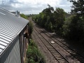 A particularly bad photo of the view south from Wotton Road bridge. However, it does show a glimpse of Charfield goods shed, which has a new roof and extension.
 -
 A separate footbridge is provided for pedestrians.
 -
 The footbridge and road bridge viewed from the west.
 -
 The view north from the bridge showing the start of Charfield Loops.


