Flour Mill: Difference between revisions
Jump to navigation
Jump to search
No edit summary |
No edit summary |
||
| (4 intermediate revisions by the same user not shown) | |||
| Line 1: | Line 1: | ||
'''To Yate''': [[Charfield Loops]] | '''To Yate''': [[Charfield Loops]] | ||
<br>'''To the North''': [[Rose]] | <br>'''To the North''': [[Rose]] | ||
== Gallery == | == Gallery == | ||
3.9.06 | |||
<gallery> | |||
Image:Flour Mill1.jpg|112M 21chns. Bristol to the left in this photo. | |||
Image:Flour Mill2.jpg|The other side of the bridge. | |||
</gallery> | |||
[[Category:Bridges]] | [[Category:Bridges]] | ||
[[Category:B&GR]] | [[Category:B&GR]] | ||
[[Category:MR]] | [[Category:MR]] | ||
Latest revision as of 19:50, 12 April 2026
To Yate: Charfield Loops
To the North: Rose
Gallery
3.9.06
-
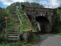 112M 21chns. Bristol to the left in this photo.
 -
 The other side of the bridge.

