Stonehouse (Bristol Road): Difference between revisions
Jump to navigation
Jump to search
No edit summary |
No edit summary |
||
| (5 intermediate revisions by the same user not shown) | |||
| Line 1: | Line 1: | ||
'''To Yate''': [[A419]]<br> | |||
'''To the North''': [[Stonedale Road Footbridge]]<br> | |||
'''To Nailsworth''': [[Midland Road Footbridge]] | |||
'''To Yate''': [[ | |||
'''To the North''': [[ | |||
'''To Nailsworth''': | |||
== History == | == History == | ||
Opened on 8th July [[1844]]. The suffix '''Bristol Road'' was added on 17th September [[1951]]. Closed to passengers on 4th January [[1965]] and goods on 3rd January [[1966]]. The redundant goods yard became the Stonehouse Coal Concentration Depot from 7th October [[1966]]. It closed in [[1989]]. | Opened on 8th July [[1844]]. The suffix '''Bristol Road''' was added on 17th September [[1951]]. Closed to passengers on 4th January [[1965]] and goods on 3rd January [[1966]]. The redundant goods yard became the Stonehouse Coal Concentration Depot from 7th October [[1966]]. It closed in [[1989]]. | ||
== Gallery == | == Gallery == | ||
12.2.09 | 12.2.09 | ||
<gallery> | <gallery> | ||
Image:Stonehouse Bristol Road1.jpg|The site of Stonehouse (Bristol Road) as viewed from the north. The mainline to Bristol curves past the surviving Station Master's house, while the route of the branch to [[Nailsworth]] curves to the left. | Image:Stonehouse Bristol Road1.jpg|The site of Stonehouse (Bristol Road) as viewed from the north. The mainline to Bristol curves past the surviving Station Master's house, while the route of the branch to [[Nailsworth]] curves to the left. | ||
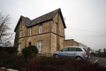
Image:Stonehouse Bristol Road5.jpg|A zoomed view showing the Station Master's house alongside the railway. | |||
Image:Stonehouse Bristol Road2.jpg|The site viewed from the south. | |||
Image:Stonehouse Bristol Road3.jpg|The boundary fence marks the route of the branch to [[Nailsworth]]. | |||
Image:Stonehouse Bristol Road4.jpg|The route south has been partially blocked by a new housing estate. | |||
Image:Stonehouse Bristol Road6.jpg|Two views of the Station Master's house. | |||
Image:Stonehouse Bristo lRoad7.jpg| | |||
</gallery> | </gallery> | ||
[[Category:Gloucester:Stations:Closed]] | [[Category:Gloucester:Stations:Closed]] | ||
[[Category:B&GR]] | [[Category:B&GR]] | ||
[[Category:MR]] | [[Category:MR]] | ||
Latest revision as of 20:20, 12 April 2026
To Yate: A419
To the North: Stonedale Road Footbridge
To Nailsworth: Midland Road Footbridge
History
Opened on 8th July 1844. The suffix Bristol Road was added on 17th September 1951. Closed to passengers on 4th January 1965 and goods on 3rd January 1966. The redundant goods yard became the Stonehouse Coal Concentration Depot from 7th October 1966. It closed in 1989.
Gallery
12.2.09
-
 The site of Stonehouse (Bristol Road) as viewed from the north. The mainline to Bristol curves past the surviving Station Master's house, while the route of the branch to Nailsworth curves to the left.
 -
 A zoomed view showing the Station Master's house alongside the railway.
 -
 The site viewed from the south.
 -
 The boundary fence marks the route of the branch to Nailsworth.
 -
 The route south has been partially blocked by a new housing estate.
 -
 Two views of the Station Master's house.
 -