A46 Bath Road: Difference between revisions
Jump to navigation
Jump to search
New page: <div style="float:right"> <googlemap lat="51.739679" lon="-2.227392"> 51.741965, -2.228036, Bath Road </googlemap> </div> '''To Dudbridge''': Dudbridge<br> '''To Stroud Wallgate''': [[... |
No edit summary |
||
| (One intermediate revision by the same user not shown) | |||
| Line 1: | Line 1: | ||
'''To Dudbridge''': [[Dudbridge]]<br> | '''To Dudbridge''': [[Dudbridge]]<br> | ||
'''To Stroud Wallgate''': [[Rodborough Hill]] | '''To Stroud Wallgate''': [[Rodborough Hill]] | ||
| Line 9: | Line 4: | ||
12.2.09 | 12.2.09 | ||
<gallery> | <gallery> | ||
Image:A46-1.jpg|The view towards [[Stroud Wallgate]]. | |||
Image:A46-2.jpg|The other side of the bridge. | |||
</gallery> | </gallery> | ||
[[Category:Gloucester:Bridges]] | [[Category:Gloucester:Bridges]] | ||
[[Category:S&NR]] | [[Category:S&NR]] | ||
Latest revision as of 20:24, 12 April 2026
To Dudbridge: Dudbridge
To Stroud Wallgate: Rodborough Hill
Gallery
12.2.09
-
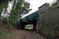 The view towards Stroud Wallgate.
 -
 The other side of the bridge.

