Wallbridge Mews: Difference between revisions
Jump to navigation
Jump to search
No edit summary |
No edit summary |
||
| (One intermediate revision by the same user not shown) | |||
| Line 1: | Line 1: | ||
'''To Dudbridge''': [[Rodborough Hill]]<br> | '''To Dudbridge''': [[Rodborough Hill]]<br> | ||
'''To Stroud Wallgate''': [[Emery Road]] | '''To Stroud Wallgate''': [[Emery Road]] | ||
| Line 11: | Line 6: | ||
Image:Wallbridge Mews1.jpg|Just a small section of bridge remains at this location. | Image:Wallbridge Mews1.jpg|Just a small section of bridge remains at this location. | ||
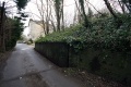
Image:Wallbridge Mews2.jpg| | Image:Wallbridge Mews2.jpg| | ||
Image:Wallbridge Mews3.jpg|The view from on top of the bridge looking in the direction of [[Stroud Wallgate]]. | |||
Image:Wallbridge Mews4.jpg|The view towards [[Dudbridge]] with the bridge at [[Rodborough Hill]] visible in the distance. | |||
</gallery> | </gallery> | ||
[[Category:Gloucester:Bridges]] | [[Category:Gloucester:Bridges]] | ||
[[Category:S&NR]] | [[Category:S&NR]] | ||
Latest revision as of 20:25, 12 April 2026
To Dudbridge: Rodborough Hill
To Stroud Wallgate: Emery Road
Gallery
12.2.09
-
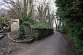 Just a small section of bridge remains at this location.
 -
-
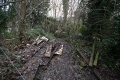 The view from on top of the bridge looking in the direction of Stroud Wallgate.
 -
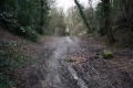 The view towards Dudbridge with the bridge at Rodborough Hill visible in the distance.


