Rose and St Mary's Crossing Halt: Difference between pages
(Difference between pages)
No edit summary |
No edit summary |
||
| Line 1: | Line 1: | ||
'''To Gloucester''': [[Brimscombe Footpath]]<br> | |||
'''To Swindon''' [[St Mary's Rail Bridge]] | |||
== Info == | |||
'''To | Opened on 12th October [[1903]] and closed in November [[1964]]. | ||
<br>'''To | |||
== Gallery == | == Gallery == | ||
<gallery> | <gallery> | ||
Image: | Image:StMary'sCrossingHalt1.jpg|The station was to the immediate left of the crossing. The signal box is still in use to control traffic across the railway. | ||
</gallery> | </gallery> | ||
[[Category: | [[Category:GWR]] | ||
[[Category: | [[Category:Gloucester:Signal Boxes]] | ||
[[Category: | [[Category:Gloucester:Stations:Closed]] | ||
Latest revision as of 20:43, 12 April 2026
To Gloucester: Brimscombe Footpath
To Swindon St Mary's Rail Bridge
Info
Opened on 12th October 1903 and closed in November 1964.
Gallery
-
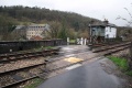 The station was to the immediate left of the crossing. The signal box is still in use to control traffic across the railway.
