A Footpath and Horton Road Level Crossing: Difference between pages
(Difference between pages)
No edit summary |
No edit summary |
||
| Line 1: | Line 1: | ||
'''To Bristol''': [[Gloucester Yard Junction]]<br> | |||
< | '''To Gloucester Central''': [[Horton Road Depot]]<br> | ||
'''To the North''': [[Barnwood Junction]]<br> | |||
'''To | |||
<br>'''To the North''': [[ | |||
== Gallery == | == Gallery == | ||
<gallery> | <gallery> | ||
Image: | Image:Horton Road Level Crossing1.jpg|Horton Road Level Crossing on a very foggy 12.12.05. | ||
Image:Horton Road Level Crossing2.jpg|The view east. The tracks curving around to the left are for trains heading north, while those on the right pass under the A4302 Metz Way before heading south. | |||
Image:Horton Road Level Crossing3.jpg|The view west with platform 1 of [[Gloucester]] station just about visible through the fog. Horton Road Junction is also known as Tramway Junction because a tramway called The Gloucester & Cheltenham Railway crossed this spot before the arrival of the railway. | |||
Image:Gloucester Area Signalling Centre1.jpg|Gloucester Area Signalling Centre sits alongside the crossing. | |||
</gallery> | </gallery> | ||
[[Category:Gloucester:Junctions]] | |||
[[Category:Gloucester:Level Crossings]] | |||
[[Category:Gloucester:Signal Boxes]] | |||
[[Category:B&GR]] | [[Category:B&GR]] | ||
[[Category:GWR]] | |||
[[Category:MR]] | [[Category:MR]] | ||
Latest revision as of 20:45, 12 April 2026
To Bristol: Gloucester Yard Junction
To Gloucester Central: Horton Road Depot
To the North: Barnwood Junction
Gallery
-
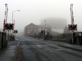 Horton Road Level Crossing on a very foggy 12.12.05.
 -
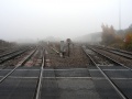 The view east. The tracks curving around to the left are for trains heading north, while those on the right pass under the A4302 Metz Way before heading south.
 -
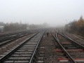 The view west with platform 1 of Gloucester station just about visible through the fog. Horton Road Junction is also known as Tramway Junction because a tramway called The Gloucester & Cheltenham Railway crossed this spot before the arrival of the railway.
 -
 Gloucester Area Signalling Centre sits alongside the crossing.


