Haresfield and Talbot Road: Difference between pages
(Difference between pages)
No edit summary |
No edit summary |
||
| Line 1: | Line 1: | ||
'''To Bristol''': [[Bath Road]] | |||
<br>'''To Radstock''': [[Brislington]] | |||
== 6.12.04 == | |||
<gallery> | |||
Image:talbotroad1.jpg|The view back towards the bridge at [[Bath Road]]. | |||
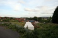
'''To Bristol''': [[ | Image:talbotroad2.jpg|An overview of the site of Brislington Station taken from Talbot Road. | ||
'''To | </gallery> | ||
== | == 2009 == | ||
<gallery> | |||
Image:BrislingtonStation6.jpg|The view of Brislington Station taken on 20.6.09. | |||
Image:TalbotRoad3.jpg|The view towards Bristol is now almost completely obscured. | |||
Image:TalbotRoad4.jpg|The bridge itself. | |||
[[Category: | </gallery> | ||
[[Category: | [[Category:Bridges]] | ||
[[Category:B&NSR]] | |||
Latest revision as of 22:36, 12 April 2026
To Bristol: Bath Road
To Radstock: Brislington
6.12.04
-
 The view back towards the bridge at Bath Road.
 -
 An overview of the site of Brislington Station taken from Talbot Road.


2009
-
 The view of Brislington Station taken on 20.6.09.
 -
 The view towards Bristol is now almost completely obscured.
 -
 The bridge itself.


