Carpenters Viaduct and Clutton: Difference between pages
(Difference between pages)
No edit summary |
|||
| Line 1: | Line 1: | ||
'''To Bristol''': [[Pensford Colliery]] | |||
<br>'''To Radstock''': [[Station Road - Clutton]] | |||
'''To | |||
'''To | |||
== History == | == History == | ||
'''Clutton Station''' was opened on 3rd September [[1873]] by the [[:Category:B&NSR|Bristol & North Somerset Railway]]. Closed to passengers on 2nd November [[1959]] and goods on 15th June [[1964]]. | |||
== Gallery == | == Gallery == | ||
<gallery> | <gallery> | ||
Image: | Image:clutton1.jpg|The remains of Clutton station looking in the direction of Bristol. Various bits of masonry still sit alongside the trackbed. | ||
Image:clutton2.jpg|Some rail is still visible onsite. This was the track that led to the goods yard. | |||
Image:clutton3.jpg|Standing at the southern extremity of the Clutton station site and looking north. The sleepers belong to A.R.M. contractors Ltd and were destined for the [[w:West_Somerset_Railway|West Somerset Railway]]. | |||
Image:clutton4.jpg|Looking south across the station site. A weighbridge house is still standing behind the truck on the left. I did have pics, but I don't anymore! | |||
</gallery> | </gallery> | ||
[[Category: | [[Category:B&NSR]] | ||
[[Category: | [[Category:Stations:Closed]] | ||
Latest revision as of 22:43, 12 April 2026
To Bristol: Pensford Colliery
To Radstock: Station Road - Clutton
History
Clutton Station was opened on 3rd September 1873 by the Bristol & North Somerset Railway. Closed to passengers on 2nd November 1959 and goods on 15th June 1964.
Gallery
-
 The remains of Clutton station looking in the direction of Bristol. Various bits of masonry still sit alongside the trackbed.
 -
 Some rail is still visible onsite. This was the track that led to the goods yard.
 -
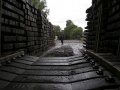 Standing at the southern extremity of the Clutton station site and looking north. The sleepers belong to A.R.M. contractors Ltd and were destined for the West Somerset Railway.
 -
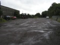 Looking south across the station site. A weighbridge house is still standing behind the truck on the left. I did have pics, but I don't anymore!


