Stratford Viaduct and Hallatrow Junction: Difference between pages
(Difference between pages)
No edit summary |
No edit summary |
||
| Line 1: | Line 1: | ||
'''To Bristol''': [[Eastcourt Road]]<br> | |||
< | '''To Monkton Combe''': [[Harts Lane]]<br> | ||
'''To Radstock''': [[Hallatrow]]<br> | |||
'''To | |||
'''To | |||
== History == | == History == | ||
== Gallery == | == Gallery == | ||
20.5.05 | |||
<gallery> | <gallery> | ||
Image: | Image:Hallatrow Junction1.jpg|The site of '''Hallatrow Junction''' in 2005. Viewed from the north, looking south. | ||
</gallery> | </gallery> | ||
[[Category: | [[Category:B&NSR]] | ||
[[Category: | [[Category:Camerton Branch]] | ||
[[Category:Junctions]] | |||
Latest revision as of 22:45, 12 April 2026
To Bristol: Eastcourt Road
To Monkton Combe: Harts Lane
To Radstock: Hallatrow
History
Gallery
20.5.05
-
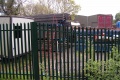 The site of Hallatrow Junction in 2005. Viewed from the north, looking south.
