Harts Lane: Difference between revisions
Jump to navigation
Jump to search
No edit summary |
|||
| (One intermediate revision by the same user not shown) | |||
| Line 1: | Line 1: | ||
'''To Monkton Combe''': [[Wells Road - A39]]<br> | '''To Monkton Combe''': [[Wells Road - A39]]<br> | ||
'''To Hallatrow''': [[Hallatrow Junction]]<br> | '''To Hallatrow''': [[Hallatrow Junction]]<br> | ||
| Line 13: | Line 8: | ||
Image:Harts Lane2.jpg|Another view showing a stream running alongside the road. | Image:Harts Lane2.jpg|Another view showing a stream running alongside the road. | ||
Image:Harts Lane3.jpg|The bridge viewed from the other side. | Image:Harts Lane3.jpg|The bridge viewed from the other side. | ||
Image:Harts Lane4.jpg|The view from on top of the bridge looking towards [[Hallatrow]]. | |||
Image:Harts Lane5.jpg|And the view towards [[Monkton Combe]]. | |||
</gallery> | </gallery> | ||
[[Category:Camerton Branch]] | [[Category:Camerton Branch]] | ||
[[Category:Bridges]] | [[Category:Bridges]] | ||
Latest revision as of 22:45, 12 April 2026
To Monkton Combe: Wells Road - A39
To Hallatrow: Hallatrow Junction
History
Gallery
20.5.05
-
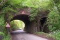
 The bridge at Harts Lane. Hallatrow is to the right in this photo.
 -
 Another view showing a stream running alongside the road.
 -
 The bridge viewed from the other side.
 -
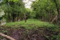 The view from on top of the bridge looking towards Hallatrow.
 -
 And the view towards Monkton Combe.


