Kemble: Difference between revisions
Jump to navigation
Jump to search
No edit summary |
No edit summary |
||
| (10 intermediate revisions by the same user not shown) | |||
| Line 1: | Line 1: | ||
'''To Gloucester''': [[St Mary's Rail Bridge]]<br> | |||
'''To Gloucester''': [[ | |||
'''To Cirencester''':<br> | '''To Cirencester''':<br> | ||
'''To Tetbury''':<br> | '''To Tetbury''':<br> | ||
| Line 23: | Line 18: | ||
Image:37410-2.jpg|[[37410]] brings up the rear of the train. | Image:37410-2.jpg|[[37410]] brings up the rear of the train. | ||
Image:Kemble7.jpg|The tour enters the 409 yard long [[Kemble Tunnel]]. The line is single track from this spot until just outside [[Swindon]]. | Image:Kemble7.jpg|The tour enters the 409 yard long [[Kemble Tunnel]]. The line is single track from this spot until just outside [[Swindon]]. | ||
Image:150244- | Image:150244-3.jpg|Standing on platform 1 and [[150244]] pulls in with a service heading north. This photo gives a bit of a look at the footbridge. | ||
</gallery> | </gallery> | ||
[[Category:GWR]] | [[Category:GWR]] | ||
[[Category:Swindon:Stations]] | [[Category:Swindon:Stations]] | ||
Latest revision as of 22:45, 4 April 2026
To Gloucester: St Mary's Rail Bridge
To Cirencester:
To Tetbury:
To Swindon Swindon
History
Opened on 1st May 1882, although a small interchange station had opened nearby on 12th May 1845. Closed to goods on 19th May 1964. A coal depot at the 1845 station site closed on 1st August 1967.
Gallery
-
 The view north from the end of platform 2. The water tower supplied Swindon Works via a 15inch pipe running alongside the railway.
 -
 And the view south from the same spot.
 -
 The main station building.
 -
 This was once the entrance for trains to Tetbury.
 -
 180102 comes to a rest at platform 2.
 -
 And then sets off again.
 -
 The view north from the footbridge.
 -
 And the view south. The track on the left is the remains of the Cirencester branch. This curves around the main station building and ends at a buffer stop in the car park.
 -
 The reason I was in Kemble in the first place... 4 X 37s on the same train.. bliss :)
 -
 37410 brings up the rear of the train.
 -
 The tour enters the 409 yard long Kemble Tunnel. The line is single track from this spot until just outside Swindon.
 -
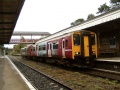 Standing on platform 1 and 150244 pulls in with a service heading north. This photo gives a bit of a look at the footbridge.


