Gough's Orchard Bridge and Lock: Difference between revisions
Jump to navigation
Jump to search
No edit summary |
No edit summary |
||
| Line 1: | Line 1: | ||
'''To the Severn''': [[Hope Mill Bridge and Lock]] | '''To the Severn''': [[Hope Mill Bridge and Lock]] | ||
<br>'''To the Thames''': [[Orchard Lane]] | <br>'''To the Thames''': [[Orchard Lane]] | ||
Latest revision as of 23:51, 17 April 2026
To the Severn: Hope Mill Bridge and Lock
To the Thames: Orchard Lane
Info
The path across the top of Gough's Orchard Bridge leads to Brimscombe Road railway bridge.
2014
29.1.14
-
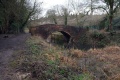 The bridge as viewed from the west. Gough's Orchard Lock is visible through the arch.
 -
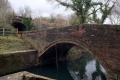 The bridge as viewed from the lock.
 -
 The view from the top of the bridge west towards Hope Mill.
 -
 The view of Gough's Orchard Lock from the bridge.
 -
 The lock viewed from the east end.
 -
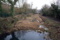
 The canal east from this point towards and through Brimscombe Port has been infilled.


