Brimscombe Port: Difference between revisions
Jump to navigation
Jump to search
No edit summary |
No edit summary |
||
| (One intermediate revision by the same user not shown) | |||
| Line 1: | Line 1: | ||
'''To the Severn''': [[Orchard Lane]]<br> | '''To the Severn''': [[Orchard Lane]]<br> | ||
'''To the Thames''': [[Bourne Mill Bridge | '''To the Thames''': [[Bourne Mill Bridge]] | ||
== Info == | == Info == | ||
[http://www.cotswoldcanalsproject.org/_documents/2_Brims%20ebulletin%20final%5B3%5D.pdf Brimscombe Port PDF showing the history and exciting future!] | [http://www.cotswoldcanalsproject.org/_documents/2_Brims%20ebulletin%20final%5B3%5D.pdf Brimscombe Port PDF showing the history and exciting future!] | ||
Latest revision as of 23:52, 17 April 2026
To the Severn: Orchard Lane
To the Thames: Bourne Mill Bridge
Info
Brimscombe Port PDF showing the history and exciting future!
2014
29.1.14
-
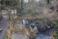 The eastern entrance to the port lies between the two archways in the distant wall.
