Whiteladies Road: Difference between revisions
Jump to navigation
Jump to search
No edit summary |
No edit summary |
||
| (One intermediate revision by the same user not shown) | |||
| Line 10: | Line 10: | ||
Image:Whiteladies Road1.jpg|Standing on '''Whiteladies Road''' looking back in the direction of [[Redland]] station. | Image:Whiteladies Road1.jpg|Standing on '''Whiteladies Road''' looking back in the direction of [[Redland]] station. | ||
Image:Whiteladies Road2.jpg|The railway squeezes through the buildings on Whiteladies Road. | Image:Whiteladies Road2.jpg|The railway squeezes through the buildings on Whiteladies Road. | ||
Image:Whiteladies Road3.jpg|The girder in this photo | Image:Whiteladies Road3.jpg|The girder in this photo is the original bridge, the shopping centre beyond is built on a concrete raft above the railway. A [[w:Sainsbury's|Sainsburys]] to the left of this photo built on the old goods yard. | ||
Image:Clifton Down3.jpg|The entrance to [[Clifton Down]] station from Whiteladies Road. | Image:Clifton Down3.jpg|The entrance to [[Clifton Down]] station from Whiteladies Road. | ||
</gallery> | </gallery> | ||
[[Category:Bridges]] | [[Category:Bridges]] | ||
[[Category:Clifton Extension Railway]] | |||
[[Category:GWR]] | [[Category:GWR]] | ||
[[Category:MR]] | |||
[[Category:The Severn Beach Line]] | [[Category:The Severn Beach Line]] | ||
Latest revision as of 13:01, 27 December 2007
<googlemap lat="51.466521" lon="-2.609253"> 51.464903, -2.610004, Whiteladies Road </googlemap>
To Bristol: Hampton Park
To Avonmouth: Clifton Down
Gallery
-
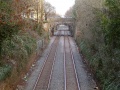 Standing on Whiteladies Road looking back in the direction of Redland station.
 -
 The railway squeezes through the buildings on Whiteladies Road.
 -
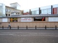 The girder in this photo is the original bridge, the shopping centre beyond is built on a concrete raft above the railway. A Sainsburys to the left of this photo built on the old goods yard.
 -
 The entrance to Clifton Down station from Whiteladies Road.


