Lower Fields: Difference between revisions
Jump to navigation
Jump to search
No edit summary |
No edit summary |
||
| (One intermediate revision by the same user not shown) | |||
| Line 1: | Line 1: | ||
'''To Yate''': [[Bath Road-Frocester|Bath Road]]<br> | '''To Yate''': [[Bath Road-Frocester|Bath Road]]<br> | ||
'''To the North''': [[ | '''To the North''': [[Stonehouse Viaduct]] | ||
== Gallery == | == Gallery == | ||
29.12.08 | 29.12.08 | ||
Latest revision as of 20:15, 12 April 2026
To Yate: Bath Road
To the North: Stonehouse Viaduct
Gallery
29.12.08
-
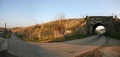
 Lower Fields in the landscape. Bristol is to the left in this photo.
 -
 A closer look at the bridge.
 -
 A Cross Country HST flies past.
 -
 The other side of the bridge.
 -
 The other side in the landscape.


