Upper Mills: Difference between revisions
Jump to navigation
Jump to search
New page: <div style="float:right"> <googlemap lat="51.738882" lon="-2.282066"> 51.741619, -2.282431, Upper Mills </googlemap> </div> '''To Stonehouse (Bristol Road)''': Boakes Drive<br> '''To N... |
No edit summary |
||
| (3 intermediate revisions by the same user not shown) | |||
| Line 1: | Line 1: | ||
'''To Stonehouse (Bristol Road)''': [[Boakes Drive]]<br> | '''To Stonehouse (Bristol Road)''': [[Boakes Drive]]<br> | ||
'''To Nailsworth''': [[Skew Bridge]] | '''To Nailsworth''': [[Skew Bridge]] | ||
| Line 9: | Line 4: | ||
12.2.09 | 12.2.09 | ||
<gallery> | <gallery> | ||
Image:Upper Mills1.jpg|The disused railway at Upper Mills. The housing estate at [[Boakes Drive]] is just visible in the distance while the [[:Category:Stroudwater Navigation|Stroudwater Navigation]] canal is visible at the left. | |||
Image:Upper Mills2.jpg|The view towards [[Stroud Wallgate|Stroud]]. The route of the railway has become a cycle path. | |||
</gallery> | </gallery> | ||
[[Category:S&NR]] | [[Category:S&NR]] | ||
[[Category:Stroudwater Navigation]] | |||
Latest revision as of 20:22, 12 April 2026
To Stonehouse (Bristol Road): Boakes Drive
To Nailsworth: Skew Bridge
Gallery
12.2.09
-
 The disused railway at Upper Mills. The housing estate at Boakes Drive is just visible in the distance while the Stroudwater Navigation canal is visible at the left.
 -
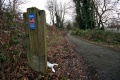 The view towards Stroud. The route of the railway has become a cycle path.

