Jeffrey's Subway: Difference between revisions
Jump to navigation
Jump to search
New page: <div style="float:right"> <googlemap lat="51.738882" lon="-2.265244"> 51.742031, -2.26578, Jeffrey's Subway </googlemap> </div> '''To Gloucester''': Brown's Lane Footbridge<br> '''To S... |
No edit summary |
||
| (2 intermediate revisions by the same user not shown) | |||
| Line 1: | Line 1: | ||
'''To Gloucester''': [[Brown's Lane Footbridge]]<br> | '''To Gloucester''': [[Brown's Lane Footbridge]]<br> | ||
'''To Swindon''' [[ | '''To Swindon''' [[Ebley Road]] | ||
== Gallery == | == Gallery == | ||
19.2.09 | 19.2.09 | ||
<gallery> | <gallery> | ||
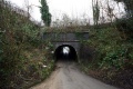
Image:Jeffrey's Subway1.jpg|The bridge leads to the Old Brickworks Industrial Estate, hence the gate. | Image:Jeffrey's Subway1.jpg|The bridge leads to the Old Brickworks Industrial Estate, hence the gate. | ||
Image:Jeffrey's Subway2.jpg|The other side of the bridge. [[Stonehouse]] is to the | Image:Jeffrey's Subway2.jpg|The other side of the bridge. [[Stonehouse]] is to the right in this photo. | ||
</gallery> | </gallery> | ||
[[Category:GWR]] | [[Category:GWR]] | ||
[[Category:Gloucester:Bridges]] | [[Category:Gloucester:Bridges]] | ||
Latest revision as of 20:34, 12 April 2026
To Gloucester: Brown's Lane Footbridge
To Swindon Ebley Road
Gallery
19.2.09
-
 The bridge leads to the Old Brickworks Industrial Estate, hence the gate.
 -
 The other side of the bridge. Stonehouse is to the right in this photo.

