Longreach Grove: Difference between revisions
Jump to navigation
Jump to search
No edit summary |
No edit summary |
||
| (One intermediate revision by one other user not shown) | |||
| Line 1: | Line 1: | ||
<div style="float:right"> | |||
<googlemap lat="51.420834" lon="-2.554665"> | |||
51.418078, -2.555158, Longreach Grove | |||
</googlemap> | |||
</div> | |||
'''To Bristol''': [[Manston Close]] | '''To Bristol''': [[Manston Close]] | ||
<br>'''To Radstock''': [[A Whitchurch Footpath]] | <br>'''To Radstock''': [[A Whitchurch Footpath]] | ||
== 5.1.05 == | |||
<gallery> | <gallery> | ||
Image:longreachgrove1.jpg|A footpath connects Longreach Grove with David's Road. Bristol is to the right in this photo. | Image:longreachgrove1.jpg|A footpath connects Longreach Grove with David's Road. Bristol is to the right in this photo. | ||
| Line 12: | Line 15: | ||
[[Category:Bridges]] | [[Category:Bridges]] | ||
[[Category: | [[Category:B&NSR]] | ||
Latest revision as of 15:56, 8 November 2007
<googlemap lat="51.420834" lon="-2.554665"> 51.418078, -2.555158, Longreach Grove </googlemap>
To Bristol: Manston Close
To Radstock: A Whitchurch Footpath
5.1.05
-
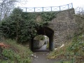 A footpath connects Longreach Grove with David's Road. Bristol is to the right in this photo.
 -
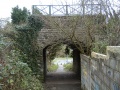 Viewed from the other side.
 -
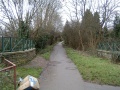
 The view north back towards Bristol.
 -
 And the view south. I don't know why I didn't boot that box into touch and get myself a better photo as a result...


