Cocklebury Lane: Difference between revisions
Jump to navigation
Jump to search
No edit summary |
No edit summary |
||
| (3 intermediate revisions by the same user not shown) | |||
| Line 1: | Line 1: | ||
'''To Chippenham''': [[Darcy Close]]<br> | '''To Chippenham''': [[Darcy Close]]<br> | ||
'''To Calne''': [[River Avon-Chippenham|River Avon]] | '''To Calne''': [[River Avon-Chippenham|River Avon]] | ||
| Line 9: | Line 4: | ||
23.10.09 | 23.10.09 | ||
<gallery> | <gallery> | ||
Image:Cocklebury Lane1.jpg|A bridge carries a country lane across the disused trackbed. This is the view in the direction of [[Calne railway station|Calne]]. | |||
Image:Cocklebury Lane2.jpg|The other side of the bridge. | |||
Image:Cocklebury Lane3.jpg|Viewed from further back. A footpath joins the trackbed on the left. | |||
Image:Cocklebury Lane4.jpg|A pipe crosses the trackbed just to the south of Cocklebury Lane. | |||
</gallery> | </gallery> | ||
[[Category:CR]] | [[Category:CR]] | ||
[[Category:Chippenham to Calne Cyclepath]] | |||
[[Category:Swindon:Bridges]] | |||
Latest revision as of 22:37, 2 August 2022
To Chippenham: Darcy Close
To Calne: River Avon
Gallery
23.10.09
-
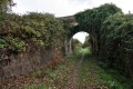 A bridge carries a country lane across the disused trackbed. This is the view in the direction of Calne.
 -
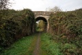 The other side of the bridge.
 -
 Viewed from further back. A footpath joins the trackbed on the left.
 -
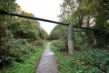 A pipe crosses the trackbed just to the south of Cocklebury Lane.


