Upper Mills Bridge: Difference between revisions
Jump to navigation
Jump to search
Created page with '<div style="float:right"> <googlemap lat="51.734311" lon="-2.281809"> 51.741646, -2.282377, Upper Mills Bridge </googlemap> </div> '''To the Severn''': Stonehouse Bridge <br>…' |
No edit summary |
||
| Line 6: | Line 6: | ||
'''To the Severn''': [[Stonehouse Bridge]] | '''To the Severn''': [[Stonehouse Bridge]] | ||
<br>'''To the Thames''': [[Skew Bridge]] | <br>'''To the Thames''': [[Skew Bridge]] | ||
== info == | |||
Originally a swing bridge which was replaced by a fixed deck. Rebuilt in 2010/11 as a high-level bridge.. | |||
== 2009 == | |||
12.2.09 | |||
<gallery> | |||
Image:UpperMills1.jpg|The view west showing the fixed bridge that previously stood at this location. | |||
Image:UpperMills2.jpg|The view west along the canal from the bridge. | |||
Image:UpperMills3.jpg|The view east. | |||
</gallery> | |||
== 2014 == | |||
6.6.14 | |||
<gallery> | |||
Image:UpperMills4.jpg|The 2014 view shows the new bridge at this location. | |||
Image:UpperMills5.jpg|The other side of the bridge. | |||
Image:UpperMills6.jpg|The view west along the canal with [[Stonehouse Bridge]] visible in the distance. | |||
</gallery> | |||
[[Category:Stroudwater Navigation]] | [[Category:Stroudwater Navigation]] | ||
Latest revision as of 17:51, 14 July 2014
<googlemap lat="51.734311" lon="-2.281809"> 51.741646, -2.282377, Upper Mills Bridge </googlemap>
To the Severn: Stonehouse Bridge
To the Thames: Skew Bridge
info
Originally a swing bridge which was replaced by a fixed deck. Rebuilt in 2010/11 as a high-level bridge..
2009
12.2.09
-
 The view west showing the fixed bridge that previously stood at this location.
 -
 The view west along the canal from the bridge.
 -
 The view east.


2014
6.6.14
-
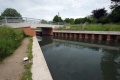 The 2014 view shows the new bridge at this location.
 -
 The other side of the bridge.
 -
 The view west along the canal with Stonehouse Bridge visible in the distance.


