Wallbridge Bridge: Difference between revisions
Jump to navigation
Jump to search
No edit summary |
No edit summary |
||
| (One intermediate revision by the same user not shown) | |||
| Line 1: | Line 1: | ||
'''To the Severn''': [[Stroud Brewery Bridge]] | '''To the Severn''': [[Stroud Brewery Bridge]] | ||
<br>'''To the Thames''': [[Wallbridge Upper Lock]] | <br>'''To the Thames''': [[Wallbridge Upper Lock]] | ||
| Line 11: | Line 6: | ||
Image:BreweryBasin.jpg|The basin between [[Stroud Brewery Bridge]] and Wallbridge Bridge. | Image:BreweryBasin.jpg|The basin between [[Stroud Brewery Bridge]] and Wallbridge Bridge. | ||
Image:WallbridgeUpperLock1.jpg|An unrestored [[Wallbridge Upper Lock]] viewed through Wallbridge Bridge. | Image:WallbridgeUpperLock1.jpg|An unrestored [[Wallbridge Upper Lock]] viewed through Wallbridge Bridge. | ||
Image:WallbridgeBridge2.jpg|A view of the basin and bridge. | |||
</gallery> | </gallery> | ||
== 2013 == | == 2013 == | ||
6.3.13 | 6.3.13 | ||
<gallery> | <gallery> | ||
Image:WallbridgeBridge1.jpg| | Image:WallbridgeBridge1.jpg|A similar view as above, but now the footpath has been restored. | ||
</gallery> | </gallery> | ||
[[Category:Thames and Severn Canal]] | [[Category:Thames and Severn Canal]] | ||
Latest revision as of 22:39, 10 July 2022
To the Severn: Stroud Brewery Bridge
To the Thames: Wallbridge Upper Lock
2009
26.1.09
-
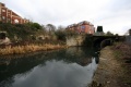
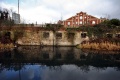 The basin between Stroud Brewery Bridge and Wallbridge Bridge.
 -
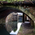 An unrestored Wallbridge Upper Lock viewed through Wallbridge Bridge.
 -
 A view of the basin and bridge.


2013
6.3.13
-
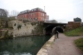 A similar view as above, but now the footpath has been restored.
