Beales Lock Bridge: Difference between revisions
Jump to navigation
Jump to search
Created page with '<div style="float:right"> <googlemap lat="51.711235" lon="-2.176951"> 51.718364, -2.177186, Beales Lock Bridge </googlemap> </div> '''To the Severn''': Bourne Bridge<br> '''T…' |
No edit summary |
||
| (2 intermediate revisions by the same user not shown) | |||
| Line 1: | Line 1: | ||
'''To the Severn''': [[Bourne Bridge]]<br> | '''To the Severn''': [[Bourne Bridge]]<br> | ||
'''To the Thames''': [[Beales Lock]] | '''To the Thames''': [[Beales Lock]] | ||
| Line 9: | Line 4: | ||
29.1.14 | 29.1.14 | ||
<gallery> | <gallery> | ||
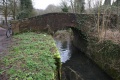
Image:BealesLockBridge1.jpg| | |||
Image:BealesLockBridge2.jpg| | |||
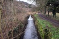
Image:BealesLockBridge3.jpg|The view west from the bridge. | |||
Image:BealesLock1.jpg|The view east with [[Beales Lock]] below. | |||
</gallery> | </gallery> | ||
[[Category:Thames and Severn Canal]] | [[Category:Thames and Severn Canal]] | ||
Latest revision as of 23:54, 17 April 2026
To the Severn: Bourne Bridge
To the Thames: Beales Lock
2014
29.1.14
-

-
-
 The view west from the bridge.
 -
 The view east with Beales Lock below.


