Parkfield Footpath: Difference between revisions
Jump to navigation
Jump to search
No edit summary |
No edit summary |
||
| (One intermediate revision by the same user not shown) | |||
| Line 1: | Line 1: | ||
<div style="float:right"> | <div style="float:right"> | ||
<googlemap lat="51. | <googlemap lat="51.489133" lon="-2.453213"> | ||
51.496214, -2.454007, Parkfield Footpath | 51.496214, -2.454007, Parkfield Footpath | ||
</googlemap> | </googlemap> | ||
| Line 9: | Line 9: | ||
A footpath crosses the old Midland Railway trackbed just south of the site of [[Parkfield Colliery]]. | A footpath crosses the old Midland Railway trackbed just south of the site of [[Parkfield Colliery]]. | ||
== Gallery == | == Gallery == | ||
21.7.05 | |||
<gallery> | <gallery> | ||
Image:Parkfield1.jpg|The view north. | Image:Parkfield1.jpg|The view north. | ||
Latest revision as of 23:33, 30 March 2012
<googlemap lat="51.489133" lon="-2.453213"> 51.496214, -2.454007, Parkfield Footpath </googlemap>
To Mangotsfield: Coxgrove Hill
To Yate:Parkfield Colliery
History
A footpath crosses the old Midland Railway trackbed just south of the site of Parkfield Colliery.
Gallery
21.7.05
-
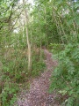 The view north.
 -
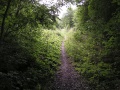 The view south.
 -
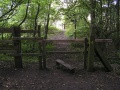 The crossing.


