Wick Lane (2): Difference between revisions
Jump to navigation
Jump to search
No edit summary |
No edit summary |
||
| (One intermediate revision by the same user not shown) | |||
| Line 1: | Line 1: | ||
'''To Yate''': [[A Footpath]] | '''To Yate''': [[A Footpath]] | ||
<br>'''To the North''': [[Wotten Road]] | <br>'''To the North''': [[Wotten Road]] | ||
| Line 14: | Line 9: | ||
Image:Wick Lane(2)4.jpg|The view north. | Image:Wick Lane(2)4.jpg|The view north. | ||
Image:Wick Lane(2)5.jpg|A zoomed view north. | Image:Wick Lane(2)5.jpg|A zoomed view north. | ||
Image:Wick Lane(2)6.jpg|There's an access point to the railway and an old hut of some sort on the south side of the bridge. | |||
</gallery> | </gallery> | ||
[[Category:Bridges]] | [[Category:Bridges]] | ||
[[Category:B&GR]] | [[Category:B&GR]] | ||
[[Category:MR]] | [[Category:MR]] | ||
Latest revision as of 19:52, 12 April 2026
To Yate: A Footpath
To the North: Wotten Road
Gallery
3.9.06
-
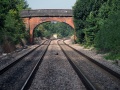 The bridge at Wick Lane as viewed from a footpath that crosses the railway just to the south.
 -
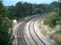
 The view south from the bridge.
 -
 A zoomed view south.
 -
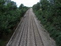 The view north.
 -
 A zoomed view north.
 -
 There's an access point to the railway and an old hut of some sort on the south side of the bridge.
1.jpg)
2.jpg)
3.jpg)
4.jpg)
5.jpg)
6.jpg)