Shirehampton: Difference between revisions
Jump to navigation
Jump to search
New page: <div style="float:right"> <googlemap lat="51.485445" lon="-2.679548"> 51.484363, -2.680235, Shirehampton </googlemap> </div> '''To Bristol''': Hung Road<br> '''To Avonmouth''': [[Stati... |
No edit summary |
||
| (7 intermediate revisions by the same user not shown) | |||
| Line 1: | Line 1: | ||
'''To Bristol''': [[Hung Road]]<br> | '''To Bristol''': [[Hung Road]]<br> | ||
'''To Avonmouth''': [[Station Road - Shirehampton|Station Road]] | '''To Avonmouth''': [[Station Road - Shirehampton|Station Road]] | ||
| Line 10: | Line 5: | ||
The goods yard was closed on 29th November [[1965]] although a private siding remained in use, serving an oil distribution company, until [[1985]]. | The goods yard was closed on 29th November [[1965]] although a private siding remained in use, serving an oil distribution company, until [[1985]]. | ||
== | == Track Plans == | ||
<gallery> | <gallery> | ||
Image: | Image:Shirehampton Track Plan 1912.jpg|A track plan of Shirehampton from the early 1900s. | ||
</gallery> | </gallery> | ||
== 1980s == | |||
<gallery> | |||
Image:Shirehampton8.jpg|A view of the main station building showing the oil distribution company occupying the site of the goods yard. 17.7.81. ''© [[:Category:Martin Potter|Martin Potter]]'' | |||
Image:B126-1.jpg|[[Class 121|Bubblecar]] [[55026|B126]] leaves the station. The oil depot can be clearly seen behind it. 7.3.87 ''© [[:Category:Andrew Bartlett|Andrew Bartlett]]'' | |||
</gallery> | |||
== 2002 == | |||
<gallery> | |||
Image:Hung Road1.jpg|The view towards [[Hung Road]]. | |||
Image:Shirehampton1.jpg|The platform shelter. | |||
Image:Shirehampton2.jpg|Next to the shelter is this rather well protected electrical cabinet. | |||
Image:Shirehampton3.jpg|An old coal office. | |||
Image:Shirehampton4.jpg|Station name board and information board located in the station carpark. | |||
Image:Shirehampton5.jpg|The view south along the station. The up platform is completely overgrown. | |||
Image:Shirehampton6.jpg|Looking towards [[Avonmouth]]. The bridge in the foreground is the one that crosses [[Station Road - Shirehampton|Station Road]]. In the background the [[w:M5 motorway|M5]] bridge across the River Avon is just visible. | |||
</gallery> | |||
[[Category:Andrew Bartlett]] | |||
[[Category:BPR&P]] | [[Category:BPR&P]] | ||
[[Category:Martin Potter]] | |||
[[Category:The Severn Beach Line]] | [[Category:The Severn Beach Line]] | ||
[[Category:Stations]] | [[Category:Stations]] | ||
Latest revision as of 17:07, 20 August 2021
To Bristol: Hung Road
To Avonmouth: Station Road
History
Opened on the 6th March 1865. This was the headquarters for the Bristol Port Railway & Pier, the company that built the section of line between Avonmouth and Hotwells.
The goods yard was closed on 29th November 1965 although a private siding remained in use, serving an oil distribution company, until 1985.
Track Plans
-
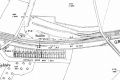 A track plan of Shirehampton from the early 1900s.

1980s
-
 A view of the main station building showing the oil distribution company occupying the site of the goods yard. 17.7.81. © Martin Potter
 -
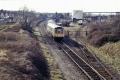 Bubblecar B126 leaves the station. The oil depot can be clearly seen behind it. 7.3.87 © Andrew Bartlett


2002
-
 The view towards Hung Road.
 -
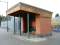 The platform shelter.
 -
 Next to the shelter is this rather well protected electrical cabinet.
 -
 An old coal office.
 -
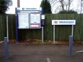 Station name board and information board located in the station carpark.
 -
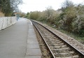 The view south along the station. The up platform is completely overgrown.
 -
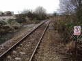 Looking towards Avonmouth. The bridge in the foreground is the one that crosses Station Road. In the background the M5 bridge across the River Avon is just visible.


