Charnhill Bridge: Difference between revisions
Jump to navigation
Jump to search
New page: <div style="float:right"> <googlemap lat="51.479138" lon="-2.493639"> 51.478319, -2.49431, Charnhill Bridge </googlemap> </div> '''To Bristol''': Tewell Hill<br> '''To Bath or the Nort... |
No edit summary |
||
| (4 intermediate revisions by the same user not shown) | |||
| Line 1: | Line 1: | ||
'''To Bristol''': [[Tewell Hill]]<br> | '''To Bristol''': [[Tewell Hill]]<br> | ||
'''To Bath or the North''': [[Bridge Road]]<br> | '''To Bath or the North''': [[Bridge Road (2)|Bridge Road]]<br> | ||
== 1960s == | == 1960s == | ||
<gallery> | <gallery> | ||
Image:Charnhill Bridge1.jpg|A local service from Bath approaches Charnhill Bridge... ''© [[:Category:Clive Moore|Clive Moore]]'' | Image:Charnhill Bridge1.jpg|A local service from [[Bath Green Park]] approaches '''Charnhill Bridge'''... ''© [[:Category:Clive Moore|Clive Moore]]'' | ||
Image:Charnhill Bridge2.jpg|...and heads off for Bristol. The lineside hut is beside the advance signal for the junction at Mangotsfield, which is where the Signal Road (on the right in the | Image:Charnhill Bridge2.jpg|...and heads off for Bristol. The lineside hut is beside the advance signal for the junction at [[Mangotsfield]], which is where the Signal Road (on the right in the photo) got its name from. Also of interest. Between the lineside hut and the garage-type building is a low area that used to be a siding access into an old quarry that got buried by a Mangotsfield council depot. ''© [[:Category:Clive Moore|Clive Moore]]'' | ||
</gallery> | |||
== 1970s == | |||
<gallery> | |||
Image:Steve Selwood1.jpg|A view of track being lifted at this location. ''© [[:Category:Steve Selwood|Steve Selwood]]'' | |||
</gallery> | </gallery> | ||
== 2005 == | == 2005 == | ||
24.3.05 | 24.3.05 | ||
<gallery> | <gallery> | ||
Image:Charnhill Bridge3.jpg|The | Image:Charnhill Bridge3.jpg|The view towards Bath ''© [[:Category:Clive Moore|Clive Moore]]'' | ||
Image:Charnhill Bridge4.jpg|And the view towards Bristol. In the 60s the inside of the bridge was clad in 6' high timbers and the lattice work wasn't visible. ''© [[:Category:Clive Moore|Clive Moore]]'' | Image:Charnhill Bridge4.jpg|And the view towards Bristol. In the 60s the inside of the bridge was clad in 6' high timbers and the lattice work wasn't visible. ''© [[:Category:Clive Moore|Clive Moore]]'' | ||
Image:Charnhill Bridge5.jpg|The view from the bridge itself. Towards Bristol. ''© [[:Category:Clive Moore|Clive Moore]]'' | Image:Charnhill Bridge5.jpg|The view from the bridge itself. Towards Bristol. ''© [[:Category:Clive Moore|Clive Moore]]'' | ||
| Line 25: | Line 24: | ||
[[Category:Bristol & Gloucestershire Railway]] | [[Category:Bristol & Gloucestershire Railway]] | ||
[[Category:Clive Moore]] | [[Category:Clive Moore]] | ||
[[Category:Steve Selwood]] | |||
Latest revision as of 17:16, 17 August 2022
To Bristol: Tewell Hill
To Bath or the North: Bridge Road
1960s
-
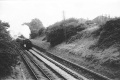 A local service from Bath Green Park approaches Charnhill Bridge... © Clive Moore
 -
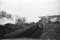 ...and heads off for Bristol. The lineside hut is beside the advance signal for the junction at Mangotsfield, which is where the Signal Road (on the right in the photo) got its name from. Also of interest. Between the lineside hut and the garage-type building is a low area that used to be a siding access into an old quarry that got buried by a Mangotsfield council depot. © Clive Moore


1970s
-
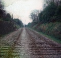 A view of track being lifted at this location. © Steve Selwood

2005
24.3.05
-
 The view towards Bath © Clive Moore
 -
 And the view towards Bristol. In the 60s the inside of the bridge was clad in 6' high timbers and the lattice work wasn't visible. © Clive Moore
 -
 The view from the bridge itself. Towards Bristol. © Clive Moore
 -
 And the view towards Bath. © Clive Moore
 -
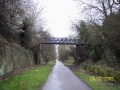
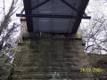
 A view of the bridge itself. © Clive Moore
 -
 The bridge pier carries the date 1900. © Clive Moore


