St Philips: Difference between revisions
Jump to navigation
Jump to search
No edit summary |
|||
| (5 intermediate revisions by the same user not shown) | |||
| Line 1: | Line 1: | ||
'''To Lawrence Hill Junction''': [[Barrow Road]] | |||
'''To Lawrence Hill Junction''': [[ | |||
== History == | == History == | ||
Opened on the 2nd of May [[1870]]. Closed to passengers on the 21st of September [[1953]] and goods on 1st April [[1967]]. | Opened on the 2nd of May [[1870]]. Closed to passengers on the 21st of September [[1953]] and goods on 1st April [[1967]]. | ||
== Track Plans == | |||
== | |||
<gallery> | <gallery> | ||
Image:St Philips1.jpg|The site of St Philips | Image:St Philips 1903.jpg|A track plan of St Philips and the surrounding railway sidings and engine sheds from [[1903]]. | ||
</gallery> | |||
== 1960s == | |||
<gallery> | |||
Image:Geograph-1909537-by-Ben-Brooksbank.jpg|A view of the then closed station. ''© [http://www.geograph.org.uk/profile/44502 Ben Brooksbank] [http://creativecommons.org/licenses/by-sa/2.0/ CC Licence]'' | |||
</gallery> | |||
== 2004 == | |||
8.8.04 | |||
<gallery> | |||
Image:St Philips1.jpg|The site of '''St Philips''' station and goods shed is now covered with an industrial estate. The giant wall at the back of the photo was the railway's boundary. | |||
</gallery> | </gallery> | ||
[[Category:MR]] | [[Category:MR]] | ||
[[Category:Stations:Closed]] | [[Category:Stations:Closed]] | ||
Latest revision as of 21:21, 14 August 2022
To Lawrence Hill Junction: Barrow Road
History
Opened on the 2nd of May 1870. Closed to passengers on the 21st of September 1953 and goods on 1st April 1967.
Track Plans
-
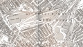 A track plan of St Philips and the surrounding railway sidings and engine sheds from 1903.

1960s
-
 A view of the then closed station. © Ben Brooksbank CC Licence

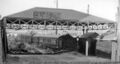
2004
8.8.04
-
 The site of St Philips station and goods shed is now covered with an industrial estate. The giant wall at the back of the photo was the railway's boundary.
