Staunton Lane: Difference between revisions
Jump to navigation
Jump to search
No edit summary |
No edit summary |
||
| (15 intermediate revisions by 3 users not shown) | |||
| Line 1: | Line 1: | ||
'''To Bristol''': [[ | <div style="float:right"> | ||
<br>'''To Radstock''': [[ | <googlemap lat="51.408147" lon="-2.555265"> | ||
51.405979, -2.555952, Staunton Lane | |||
</googlemap> | |||
</div> | |||
'''To Bristol''': [[Sturminster Road]] | |||
<br>'''To Radstock''': [[A37 Bristol Road]] | |||
== 5.1.05 == | |||
<gallery> | <gallery> | ||
Image:stauntonlane1.jpg|The view north with a strip of greenery marking the route of the railway back towards Bristol. | Image:stauntonlane1.jpg|The view north with a strip of greenery marking the route of the railway back towards Bristol. | ||
Image:stauntonlane2.jpg|Turning around and the route is now a carpark for the [ | Image:stauntonlane2.jpg|Turning around and the route is now a carpark for the [[w:Royal British Legion|Royal British Legion]]. | ||
Image:stauntonlane3.jpg|This memorial has been built on the exact spot where the bridge used to be that took Staunton Lane over the railway. | Image:stauntonlane3.jpg|This memorial has been built on the exact spot where the bridge used to be that took Staunton Lane over the railway. | ||
Image:stauntonlane4.jpg|Standing on Staunton Lane and looking north back along the route of the railway. | Image:stauntonlane4.jpg|Standing on Staunton Lane and looking north back along the route of the railway. | ||
Image:stauntonlane5.jpg|Nothing of the route south exists from this point until the [ | Image:stauntonlane5.jpg|Nothing of the route south exists from this point until the [[A37 Bristol Road|A37]] at [[w:Whitchurch|Whitchurch]]. The area is now a drab housing estate. | ||
</gallery> | </gallery> | ||
[[Category:Bridges:Demolished]] | |||
[[Category: | [[Category:B&NSR]] | ||
Latest revision as of 13:24, 9 January 2008
<googlemap lat="51.408147" lon="-2.555265"> 51.405979, -2.555952, Staunton Lane </googlemap>
To Bristol: Sturminster Road
To Radstock: A37 Bristol Road
5.1.05
-
 The view north with a strip of greenery marking the route of the railway back towards Bristol.
 -
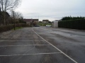 Turning around and the route is now a carpark for the Royal British Legion.
 -
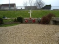 This memorial has been built on the exact spot where the bridge used to be that took Staunton Lane over the railway.
 -
 Standing on Staunton Lane and looking north back along the route of the railway.
 -
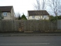 Nothing of the route south exists from this point until the A37 at Whitchurch. The area is now a drab housing estate.


