Holesmouth Junction: Difference between revisions
Jump to navigation
Jump to search
No edit summary |
No edit summary |
||
| (2 intermediate revisions by the same user not shown) | |||
| Line 1: | Line 1: | ||
'''To Avonmouth''': [[St Andrews Road]]<br> | '''To Avonmouth''': [[St Andrews Road]]<br> | ||
'''To Hallen Marsh Junction''': [[Hallen Marsh Junction]]<br> | '''To Hallen Marsh Junction''': [[Hallen Marsh Junction]]<br> | ||
'''To West Wharf''': [[Avonmouth West Wharf]]<br> | '''To West Wharf''': [[Avonmouth West Wharf]]<br> | ||
'''To Avonmouth BP Oil''': [[Avonmouth BP Oil]] | '''To Avonmouth BP Oil''': [[Avonmouth BP Oil]] | ||
== Track Plans == | |||
<gallery> | |||
Image:Holesmouth Junction Track Plan 1988.jpg|A track plan of Holesmouth Junction and surrounding area from 1988. | |||
</gallery> | |||
== 1980s == | == 1980s == | ||
<gallery> | <gallery> | ||
Image:Holesmouth Junction1.jpg|A train of coal empties enters [[St Andrews Road|Royal Edward | Image:Holesmouth Junction1.jpg|A train of coal empties enters [[St Andrews Road|Royal Edward Yard]], late 1981. ''© [[:Category:Peter Rendall|P.D.Rendall/Past-Track Publications]]'' | ||
Image:Holesmouth Junction2.jpg|PBA39 scuttles past Holesmouth Junction signal box en-route to the [[Chittening Trading Estate]]. Early 1982. At the time of writing this loco is preserved at the East Somerset Railway. ''© [[:Category:Peter Rendall|P.D.Rendall/Past-Track Publications]]'' | Image:Holesmouth Junction2.jpg|PBA39 scuttles past Holesmouth Junction signal box en-route to the [[Chittening Trading Estate]]. Early 1982. At the time of writing this loco is preserved at the East Somerset Railway. ''© [[:Category:Peter Rendall|P.D.Rendall/Past-Track Publications]]'' | ||
Image:Holesmouth Junction3.jpg|Holesmouth Junction signalbox looking towards [[Hallen Marsh Junction]]. Hallen Marsh signalbox can be seen in the distance. 1983. ''© [[:Category:Peter Rendall|P.D.Rendall/Past-Track Publications]]'' | Image:Holesmouth Junction3.jpg|Holesmouth Junction signalbox looking towards [[Hallen Marsh Junction]]. Hallen Marsh signalbox can be seen in the distance. 1983. ''© [[:Category:Peter Rendall|P.D.Rendall/Past-Track Publications]]'' | ||
Image:Holesmouth Junction4.jpg|Viewed from the bridge by the fuel terminals, looking towards Holesmouth and Avonmouth. St Andrews Rd/Smoke Lane to the left, Docks to the right. ''© [[:Category:Peter Rendall|P.D.Rendall/Past-Track Publications]]'' | Image:Holesmouth Junction4.jpg|Viewed from the bridge by the fuel terminals, looking towards Holesmouth and Avonmouth. St Andrews Rd/Smoke Lane to the left, Docks to the right. ''© [[:Category:Peter Rendall|P.D.Rendall/Past-Track Publications]]'' | ||
</gallery> | </gallery> | ||
== 2005 == | == 2005 == | ||
<gallery> | <gallery> | ||
Latest revision as of 10:05, 7 May 2018
To Avonmouth: St Andrews Road
To Hallen Marsh Junction: Hallen Marsh Junction
To West Wharf: Avonmouth West Wharf
To Avonmouth BP Oil: Avonmouth BP Oil
Track Plans
-
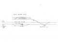 A track plan of Holesmouth Junction and surrounding area from 1988.

1980s
-
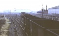 A train of coal empties enters Royal Edward Yard, late 1981. © P.D.Rendall/Past-Track Publications
 -
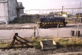 PBA39 scuttles past Holesmouth Junction signal box en-route to the Chittening Trading Estate. Early 1982. At the time of writing this loco is preserved at the East Somerset Railway. © P.D.Rendall/Past-Track Publications
 -
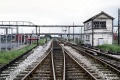 Holesmouth Junction signalbox looking towards Hallen Marsh Junction. Hallen Marsh signalbox can be seen in the distance. 1983. © P.D.Rendall/Past-Track Publications
 -
 Viewed from the bridge by the fuel terminals, looking towards Holesmouth and Avonmouth. St Andrews Rd/Smoke Lane to the left, Docks to the right. © P.D.Rendall/Past-Track Publications


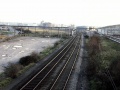
2005
-
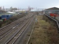 A similar view of the junction taken on 16.1.05.
