South Liberty Colliery: Difference between revisions
Jump to navigation
Jump to search
No edit summary |
No edit summary |
||
| (7 intermediate revisions by the same user not shown) | |||
| Line 1: | Line 1: | ||
'''To Bristol''': [[West Junction]]<br> | '''To Bristol''': [[West Junction]]<br> | ||
'''To the Southwest''': [[Brook Gate]] | '''To the Southwest''': [[Brook Gate]] | ||
== Track Plans == | == Track Plans == | ||
<gallery> | <gallery> | ||
| Line 13: | Line 6: | ||
Image:Flax Bourton Area Track Plan 1988.jpg|A track plan of the area from [[1988]] showing '''South Liberty Junction''' and a connection with [[West Depot]] . | Image:Flax Bourton Area Track Plan 1988.jpg|A track plan of the area from [[1988]] showing '''South Liberty Junction''' and a connection with [[West Depot]] . | ||
</gallery> | </gallery> | ||
== 1960s == | |||
<gallery> | <gallery> | ||
Image:South Liberty | Image:South Liberty Lane28.jpg|Two views of the bridge in the 1960s. There's a signal in front of the bridge in a cage. ''© [[:Category:Emmdee|Emmdee]]'' | ||
Image: | Image:SouthLibertyLane29.jpg|''© [[:Category:Emmdee|Emmdee]]'' | ||
Image: | Image:West Depot5.jpg|A superb view of a [[Class 52|Western]] hauling a freight out of [[West Depot]]. ''© [[:Category:Andy Kirkham|Andy Kirkham]]'' | ||
</gallery> | </gallery> | ||
== 1989 == | == 1989 == | ||
<gallery> | <gallery> | ||
Image:47817South Liberty Lane1989.jpg|[[47817]] accelerates hard under the footbridge as it heads for Plymouth. The track on the left is the container depot headshunt, while the track on the right is a headshunt for | Image:47817South Liberty Lane1989.jpg|[[47817]] accelerates hard under the footbridge as it heads for [[Plymouth]]. The track on the left is the container depot headshunt, while the track on the right is a headshunt for [[West Depot|West Depot Down Carriage Yard]]. | ||
Image:HSTSouth Liberty Lane1989.jpg|An HST powers towards | Image:HSTSouth Liberty Lane1989.jpg|An [[Class 43|HST]] powers towards [[Temple Meads]]. In the far distance a [[Class 47]] can just be seen standing light-engine in the run round loop at the [[West Depot|container depot]]. | ||
Image:47524South Liberty Lane1989.jpg|Looking in the opposite direction and [[47524]] runs light engine towards Bristol | Image:47524South Liberty Lane1989.jpg|Looking in the opposite direction and [[47524]] runs light engine towards Bristol. | ||
</gallery> | </gallery> | ||
== 2003 == | == 2003 == | ||
18.11.03 | |||
<gallery> | <gallery> | ||
Image:South Liberty Lane11.jpg|A similar view to the first two shots in 1989. Although invisible in this shot, the headshunt for the old container depot is still there albeit buried under all that undergrowth. | Image:South Liberty Lane10.jpg|A view of the footbridge taken from the Bedminster Down side of the track. | ||
Image:South Liberty Lane12.jpg|Another view of the line and an HST | Image:South Liberty Lane17.jpg|A side view of the bridge showing the lovely cast iron pillars holding it up. The bridge was originally a crossing place for miners who lived in Bedminster Down and worked at South Liberty Colliery. | ||
Image:South Liberty Lane11.jpg|A similar view to the first two shots in 1989. Although invisible in this shot, the headshunt for the old container depot is still there, albeit buried under all that undergrowth. | |||
Image:South Liberty Lane12.jpg|Another view of the line and an [[Class 43|HST]] heads into Bristol. In the far distance [[Bedminster Down Road]] bridge can be seen. The tall lighting towers are where the [[West Depot|container depot]] used to be. | |||
Image:South Liberty Lane13.jpg|The same view as the third shot in 1989. [[150234]] slows on the approach to [[Parson Street]]. The remains of the container depot headshunt is clearly visible in this shot. | Image:South Liberty Lane13.jpg|The same view as the third shot in 1989. [[150234]] slows on the approach to [[Parson Street]]. The remains of the container depot headshunt is clearly visible in this shot. | ||
Image:South Liberty Lane9.jpg|The approach to the footbridge from South Liberty Lane. | |||
</gallery> | </gallery> | ||
== 2006== | == 2006== | ||
| Line 37: | Line 34: | ||
Image:South Liberty Lane23.jpg|The view west. Again, not much has changed. | Image:South Liberty Lane23.jpg|The view west. Again, not much has changed. | ||
Image:South Liberty Lane24.jpg|A zoomed view showing an old buffer stop buried in the vegetation. | Image:South Liberty Lane24.jpg|A zoomed view showing an old buffer stop buried in the vegetation. | ||
Image:South Liberty Lane25.jpg| | Image:South Liberty Lane26.jpg|Work was taking place to make the embankment smaller so that a large industrial unit could be constructed. | ||
Image:South Liberty Lane27.jpg| | |||
Image:South Liberty Lane25.jpg|As a result of the construction work the approach to the bridge has become much more user friendly. | |||
</gallery> | |||
== 2018 == | |||
3.5.18 | |||
<gallery> | |||
Image:Southlibertylane28.jpg|Since my last visit the Freightliner depot has reopened and the headshunt has been put back into use. | |||
Image:Southlibertylane29.jpg| | |||
</gallery> | </gallery> | ||
[[Category:B&ER]] | [[Category:B&ER]] | ||
[[Category:Bridges:Footbridges]] | [[Category:Bridges:Footbridges]] | ||
[[Category:Collieries]] | [[Category:Collieries]] | ||
[[Category:Emmdee]] | |||
[[Category:Andy Kirkham]] | |||
Latest revision as of 21:36, 3 May 2018
To Bristol: West Junction
To the Southwest: Brook Gate
Track Plans
-
 A map from the early 1900s showing the colliery.
 -
 A track plan of the area from 1988 showing South Liberty Junction and a connection with West Depot .


1960s
-
 Two views of the bridge in the 1960s. There's a signal in front of the bridge in a cage. © Emmdee
 -
 © Emmdee
 -


1989
-
47817 accelerates hard under the footbridge as it heads for Plymouth. The track on the left is the container depot headshunt, while the track on the right is a headshunt for West Depot Down Carriage Yard.
-
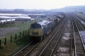
An HST powers towards Temple Meads. In the far distance a Class 47 can just be seen standing light-engine in the run round loop at the container depot.
-
Looking in the opposite direction and 47524 runs light engine towards Bristol.
2003
18.11.03
-
A view of the footbridge taken from the Bedminster Down side of the track.
-
A side view of the bridge showing the lovely cast iron pillars holding it up. The bridge was originally a crossing place for miners who lived in Bedminster Down and worked at South Liberty Colliery.
-
A similar view to the first two shots in 1989. Although invisible in this shot, the headshunt for the old container depot is still there, albeit buried under all that undergrowth.
-
Another view of the line and an HST heads into Bristol. In the far distance Bedminster Down Road bridge can be seen. The tall lighting towers are where the container depot used to be.
-
The same view as the third shot in 1989. 150234 slows on the approach to Parson Street. The remains of the container depot headshunt is clearly visible in this shot.
-
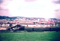
The approach to the footbridge from South Liberty Lane.
2006
18th July
-
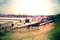
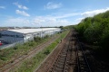
The view towards Bristol. Not much changed since my earlier visit.
-
The view west. Again, not much has changed.
-
A zoomed view showing an old buffer stop buried in the vegetation.
-
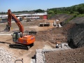
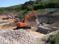 Work was taking place to make the embankment smaller so that a large industrial unit could be constructed.
 -
-
As a result of the construction work the approach to the bridge has become much more user friendly.


2018
3.5.18
-
 Since my last visit the Freightliner depot has reopened and the headshunt has been put back into use.
 -


