Hodshill: Difference between revisions
Jump to navigation
Jump to search
BristleGWR (talk | contribs) New page: <div style="float:right"> <googlemap lat="51.341866" lon="-2.364432"> 51.341732, -2.364399, Hodshill </googlemap> </div> '''To Monkton Combe''': Cam Brook Viaduct<br> '''To Hallatrow''... |
No edit summary |
||
| (3 intermediate revisions by one other user not shown) | |||
| Line 1: | Line 1: | ||
'''To Monkton Combe''': [[Cam Brook Viaduct]]<br> | '''To Monkton Combe''': [[Cam Brook Viaduct]]<br> | ||
'''To Hallatrow''': [[]]<br> | '''To Hallatrow''': [[Limestone Link (Engine Wood)]]<br> | ||
== History == | == History == | ||
== Gallery == | == Gallery == | ||
== 2008 == | |||
8th June | |||
<gallery> | <gallery> | ||
Image:Hodshill2a.jpg|A stitched together view of the sharp bend in the road where the railway once was. Not easily visible in the photo are a number of pieces of rail placed upright in the ground just behind the fence. ''© [[:Category:Ian Tiley|Ian Tiley]]'' | |||
</gallery> | </gallery> | ||
[[Category:Camerton Branch]] | [[Category:Camerton Branch]] | ||
[[Category:Bridges:Demolished]] | [[Category:Bridges:Demolished]] | ||
[[Category: | [[Category:Ian Tiley]] | ||
Latest revision as of 22:54, 12 April 2026
To Monkton Combe: Cam Brook Viaduct
To Hallatrow: Limestone Link (Engine Wood)
History
Gallery
2008
8th June
-
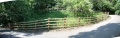 A stitched together view of the sharp bend in the road where the railway once was. Not easily visible in the photo are a number of pieces of rail placed upright in the ground just behind the fence. © Ian Tiley