Dryleaze: Difference between revisions
Jump to navigation
Jump to search
No edit summary |
|||
| (One intermediate revision by the same user not shown) | |||
| Line 1: | Line 1: | ||
'''To Bristol, the North or Wales''': [[Keynsham Hams]] | '''To Bristol, the North or Wales''': [[Keynsham Hams]] | ||
<br>'''To Bath''':[[Station Road-Keynsham]] | <br>'''To Bath''':[[Station Road-Keynsham]] | ||
| Line 10: | Line 5: | ||
== Gallery == | == Gallery == | ||
5.3.08 | |||
<gallery> | <gallery> | ||
Image:Dryleaze1.jpg|The bridge at Dryleaze viewed from the north. | Image:Dryleaze1.jpg|The bridge at Dryleaze viewed from the north. | ||
Latest revision as of 21:01, 28 July 2022
To Bristol, the North or Wales: Keynsham Hams
To Bath:Station Road-Keynsham
History
This bridge used to lead to farmers fields, but the route is now blocked by the Keynsham Bypass.
Gallery
5.3.08
-
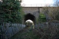 The bridge at Dryleaze viewed from the north.
 -
 The other side of the bridge.

