Pensford Hill: Difference between revisions
Jump to navigation
Jump to search
No edit summary |
No edit summary |
||
| (One intermediate revision by the same user not shown) | |||
| Line 1: | Line 1: | ||
'''To Bristol''': [[Parsonage Lane]] | '''To Bristol''': [[Parsonage Lane]] | ||
<br>'''To Radstock''': [[Pensford]] | <br>'''To Radstock''': [[Pensford]] | ||
== Gallery == | == Gallery == | ||
20.5.05 | |||
<gallery> | <gallery> | ||
Image:Pensford Hill1.jpg|The view north across '''Pensford Hill''' showing a surviving bridge abutment and the railway embankment beyond. | Image:Pensford Hill1.jpg|The view north across '''Pensford Hill''' showing a surviving bridge abutment and the railway embankment beyond. | ||
</gallery> | </gallery> | ||
[[Category:B&NSR]] | [[Category:B&NSR]] | ||
Latest revision as of 22:41, 12 April 2026
To Bristol: Parsonage Lane
To Radstock: Pensford
Gallery
20.5.05
-
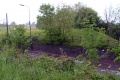 The view north across Pensford Hill showing a surviving bridge abutment and the railway embankment beyond.
