Bleadon and Uphill: Difference between revisions
Jump to navigation
Jump to search
No edit summary |
No edit summary |
||
| (2 intermediate revisions by the same user not shown) | |||
| Line 1: | Line 1: | ||
'''To Weston Super Mare''': [[A370 Bridgwater Road]]<br> | '''To Weston Super Mare''': [[A370 Bridgwater Road]]<br> | ||
'''To the Southwest''': [[ | '''To the Southwest''': [[Market Street]]<br> | ||
== History == | == History == | ||
Opened as '''Uphill''' in [[1871]]. Renamed '''Bleadon and Uphill''' in [[1872]]. Unstaffed from 2nd November [[1959]]. Closed on 5th October [[1964]]. | Opened as '''Uphill''' in [[1871]]. Renamed '''Bleadon and Uphill''' in [[1872]]. Unstaffed from 2nd November [[1959]]. Closed on 5th October [[1964]]. | ||
Latest revision as of 22:50, 14 April 2026
To Weston Super Mare: A370 Bridgwater Road
To the Southwest: Market Street
History
Opened as Uphill in 1871. Renamed Bleadon and Uphill in 1872. Unstaffed from 2nd November 1959. Closed on 5th October 1964.
Gallery
-
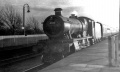 4985 rushing through Bleadon and Uphill station. © John Thorn
