A4 Bristol Road: Difference between revisions
Jump to navigation
Jump to search
BristleGWR (talk | contribs) No edit summary |
No edit summary |
||
| Line 1: | Line 1: | ||
<div style="float:right"> | <div style="float:right"> | ||
<googlemap lat="51. | <googlemap lat="51.38212" lon="-2.416134"> | ||
51.38812, -2.416563, A4 Bristol Road | 51.38812, -2.416563, A4 Bristol Road | ||
</googlemap> | </googlemap> | ||
</div> | </div> | ||
'''To Bristol''': [[ | '''To Bristol''': [[110M 10C]] | ||
<br>'''To Bath''': [[Twerton Meadows]] | <br>'''To Bath''': [[Twerton Meadows]] | ||
== Gallery == | == Gallery == | ||
<gallery> | <gallery> | ||
Image:A4_Bristol_Road1.jpg|The east side of the bridge as viewed from the bridge at [[Twerton Meadows]]. ''© [[:Category:Ian Tiley|Ian Tiley]]'' | Image:A4_Bristol_Road1.jpg|The east side of the bridge as viewed from the bridge at [[Twerton Meadows]]. ''© [[:Category:Ian Tiley|Ian Tiley]]'' | ||
</gallery> | </gallery> | ||
[[Category:Bridges]] | [[Category:Bridges]] | ||
[[Category:GWR]] | [[Category:GWR]] | ||
[[Category:Ian Tiley]] | [[Category:Ian Tiley]] | ||
Revision as of 18:22, 2 December 2009
<googlemap lat="51.38212" lon="-2.416134"> 51.38812, -2.416563, A4 Bristol Road </googlemap>
To Bristol: 110M 10C
To Bath: Twerton Meadows
Gallery
-
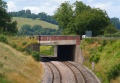 The east side of the bridge as viewed from the bridge at Twerton Meadows. © Ian Tiley
